
New Orleans, LA
New Orleans, LA
10
10
0
=================================================
BULLETIN
Hurricane Delta Intermediate Advisory Number 15A
NWS National Hurricane Center Miami FL AL262020
700 AM CDT Thu Oct 08 2020
...NOAA AND AIR FORCE RESERVE HURRICANE HUNTER AIRCRAFT
INVESTIGATING DELTA...
...HURRICANE CONDITIONS AND LIFE-THREATENING STORM SURGE EXPECTED
TO BEGIN ALONG PORTIONS OF THE NORTHERN GULF COAST ON FRIDAY...
SUMMARY OF 700 AM CDT...1200 UTC...INFORMATION
----------------------------------------------
LOCATION...23.7N 92.3W
ABOUT 425 MI...685 KM S OF CAMERON LOUISIANA
MAXIMUM SUSTAINED WINDS...100 MPH...155 KM/H
PRESENT MOVEMENT...NW OR 305 DEGREES AT 15 MPH...24 KM/H
MINIMUM CENTRAL PRESSURE...970 MB...28.64 INCHES
WATCHES AND WARNINGS
--------------------
CHANGES WITH THIS ADVISORY:
The Storm Surge Watch has been discontinued from east of Ocean
Springs, Mississippi, to the Mississippi/Alabama border.
SUMMARY OF WATCHES AND WARNINGS IN EFFECT:
A Storm Surge Warning is in effect for...
* Sabine Pass to Ocean Springs, Mississippi including Calcasieu
Lake, Vermilion Bay, Lake Pontchartrain, Lake Maurepas, and Lake
Borgne
A Storm Surge Watch is in effect for...
* High Island, TX to Sabine Pass
A Hurricane Warning is in effect for...
* East of Sabine Pass to Morgan City, Louisiana
A Tropical Storm Warning is in effect for...
* San Luis Pass, Texas to Sabine Pass
* East of Morgan City, Louisiana to the mouth of the Pearl River,
including New Orleans
* Lake Pontchartrain and Lake Maurepas
A Tropical Storm Watch is in effect for...
* East of the mouth of the Pearl River to Bay St. Louis Mississippi
A Storm Surge Warning means there is a danger of life-threatening
inundation, from rising water moving inland from the coastline,
during the next 36 hours in the indicated locations. For a
depiction of areas at risk, please see the National Weather
Service Storm Surge Watch/Warning Graphic, available at
hurricanes.gov. This is a life-threatening situation. Persons
located within these areas should take all necessary actions to
protect life and property from rising water and the potential for
other dangerous conditions. Promptly follow evacuation and other
instructions from local officials.
A Storm Surge Watch means there is a possibility of life-
threatening inundation, from rising water moving inland from the
coastline, in the indicated locations during the next 48 hours.
For a depiction of areas at risk, please see the National Weather
Service Storm Surge Watch/Warning Graphic, available at
hurricanes.gov.
A Hurricane Warning means that hurricane conditions are expected
somewhere within the warning area. A warning is typically issued
36 hours before the anticipated first occurrence of
tropical-storm-force winds, conditions that make outside
preparations difficult or dangerous. Preparations to protect life
and property should be rushed to completion.
A Tropical Storm Warning means that tropical storm conditions are
expected somewhere within the warning area.
A Tropical Storm Watch means that tropical storm conditions are
possible within the watch area.
For storm information specific to your area, please monitor
products issued by your national meteorological service.
DISCUSSION AND OUTLOOK
----------------------
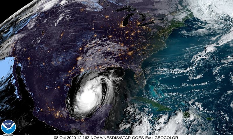
At 700 AM CDT (1200 UTC), the center of Hurricane Delta was located
by NOAA and Air Force Reserve Hurricane Hunter aircraft near
latitude 23.7 North, longitude 92.3 West. Delta is moving toward
the northwest near 15 mph (24 km/h), and this motion with a
reduction in forward speed is expected today. A turn to the north
is forecast to occur by late tonight, followed by a north-
northeastward motion by Friday night. On the forecast track, the
center of Delta will move over the central Gulf of Mexico today,
and move inland within the hurricane warning area Friday afternoon
or Friday night.
Reports from the Hurricane Hunter aircraft indicate that maximum
sustained winds are near 100 mph (155 km/h) with higher gusts.
Strengthening is forecast, and Delta is expected to become a
major hurricane again by tonight. Some weakening is forecast when
Delta approaches the northern Gulf coast on Friday.
Hurricane-force winds extend outward up to 35 miles (55 km) from
the center and tropical-storm-force winds extend outward up to 125
miles (205 km).
The minimum central pressure just reported by the Hurricane Hunter
aircraft is 970 mb (28.64 inches).
HAZARDS AFFECTING LAND
----------------------
Key messages for Delta can be found in the Tropical Cyclone
Discussion under AWIPS header MIATCDAT1, WMO header WTNT41
KNHC, and on the web at http://www.hurricanes.gov/text/MIATCDAT1.shtml.
STORM SURGE: The combination of a dangerous storm surge and the
tide will cause normally dry areas near the coast to be flooded by
rising waters moving inland from the shoreline. The water could
reach the following heights above ground somewhere in the indicated
areas if the peak surge occurs at the time of high tide...
Pecan Island, LA to Port Fourchon, LA including Vermilion Bay...
7-11 ft
Cameron, LA to Pecan Island, LA...4-7 ft
Port Fourchon, LA to the Mouth of the Mississippi River4-6 ft
Mouth of the Mississippi River to Ocean Springs, MS...2-4 ft
Lake Borgne, Lake Pontchartrain, and Lake Maurepas...2-4 ft
High Island, TX to Cameron, LA including Calcasieu Lake...2-4 ft
Ocean Springs, MS to the AL/FL border including Mobile Bay...1-3 ft
Sabine Lake...1-3 ft
Port O'Connor, TX to High Island, TX including Galveston Bay...
1-3 ft
The deepest water will occur along the immediate coast near and to
the east of the landfall location, where the surge will be
accompanied by large and dangerous waves. Surge-related flooding
depends on the relative timing of the surge and the tidal cycle,
and can vary greatly over short distances. For information
specific to your area, please see products issued by your local
National Weather Service forecast office.
WIND: Hurricane conditions are expected within the hurricane
warning area by Friday afternoon or evening, with tropical storm
conditions expected within this area by early Friday. Tropical
storm conditions are expected within the tropical storm warning
areas on Friday.
RAINFALL: Friday through Saturday, Delta is expected to produce 5
to 10 inches of rain, with isolated maximum totals of 15 inches,
for southwest into south central Louisiana. These rainfall amounts
will lead to significant flash, urban, small stream flooding, along
with minor to isolated moderate river flooding.
For extreme east Texas into northern Louisiana, southern Arkansas
and western Mississippi, Delta is expected to produce 3 to 6 inches
of rain, with isolated maximum totals of 10 inches. These rainfall
amounts will lead to flash, urban, small stream and isolated minor
river flooding.
As Delta moves farther inland, 1 to 3 inches of rain, with locally
higher amounts, are expected in the Ohio Valley and Mid Atlantic
this weekend.
TORNADOES: A few tornadoes are possible late tonight through Friday
over southern parts of Louisiana and Mississippi
SURF: Swells from Delta will begin to affect portions of the
northern and western Gulf coast later today. These swells are
likely to cause life-threatening surf and rip current conditions.
Please consult products from your local weather office.
NEXT ADVISORY
-------------
Next complete advisory at 1000 AM CDT.
====================================================
NWS NATIONAL HURRICANE CENTER MIAMI FL AL [login to see] UTC THU OCT 08 2020
CHANGES IN WATCHES AND WARNINGS WITH THIS ADVISORY...
NONE.
SUMMARY OF WATCHES AND WARNINGS IN EFFECT...
A STORM SURGE WARNING IS IN EFFECT FOR...
* SABINE PASS TO OCEAN SPRINGS...MISSISSIPPI INCLUDING CALCASIEU
LAKE...VERMILION BAY...LAKE PONTCHARTRAIN...LAKE MAUREPAS...AND LAKE
BORGNE
A STORM SURGE WATCH IS IN EFFECT FOR...
* HIGH ISLAND...TX TO SABINE PASS
* EAST OF OCEAN SPRINGS...MISSISSIPPI TO THE MISSISSIPPI/ALABAMA
BORDER
A HURRICANE WARNING IS IN EFFECT FOR...
* EAST OF SABINE PASS TO MORGAN CITY...LOUISIANA
A TROPICAL STORM WARNING IS IN EFFECT FOR...
* SAN LUIS PASS...TEXAS TO SABINE PASS
* EAST OF MORGAN CITY...LOUISIANA TO THE MOUTH OF THE PEARL
RIVER...INCLUDING NEW ORLEANS
* LAKE PONTCHARTRAIN AND LAKE MAUREPAS
A TROPICAL STORM WATCH IS IN EFFECT FOR...
* EAST OF THE MOUTH OF THE PEARL RIVER TO BAY ST. LOUIS MISSISSIPPI
A STORM SURGE WARNING MEANS THERE IS A DANGER OF LIFE-THREATENING
INUNDATION...FROM RISING WATER MOVING INLAND FROM THE
COASTLINE...DURING THE NEXT 36 HOURS IN THE INDICATED LOCATIONS.
FOR A
DEPICTION OF AREAS AT RISK...PLEASE SEE THE NATIONAL WEATHER
SERVICE STORM SURGE WATCH/WARNING GRAPHIC...AVAILABLE AT
HURRICANES.GOV. THIS IS A LIFE-THREATENING SITUATION. PERSONS
LOCATED WITHIN THESE AREAS SHOULD TAKE ALL NECESSARY ACTIONS TO
PROTECT LIFE AND PROPERTY FROM RISING WATER AND THE POTENTIAL FOR
OTHER DANGEROUS CONDITIONS. PROMPTLY FOLLOW EVACUATION AND OTHER
INSTRUCTIONS FROM LOCAL OFFICIALS.
A STORM SURGE WATCH MEANS THERE IS A POSSIBILITY OF LIFE-
THREATENING INUNDATION...FROM RISING WATER MOVING INLAND FROM THE
COASTLINE...IN THE INDICATED LOCATIONS DURING THE NEXT 48 HOURS.
FOR A DEPICTION OF AREAS AT RISK...PLEASE SEE THE NATIONAL WEATHER
SERVICE STORM SURGE WATCH/WARNING GRAPHIC...AVAILABLE AT
HURRICANES.GOV.
A HURRICANE WARNING MEANS THAT HURRICANE CONDITIONS ARE EXPECTED
SOMEWHERE WITHIN THE WARNING AREA. A WARNING IS TYPICALLY ISSUED
36 HOURS BEFORE THE ANTICIPATED FIRST OCCURRENCE OF
TROPICAL-STORM-FORCE WINDS...CONDITIONS THAT MAKE OUTSIDE
PREPARATIONS DIFFICULT OR DANGEROUS. PREPARATIONS TO PROTECT LIFE
AND PROPERTY SHOULD BE RUSHED TO COMPLETION.
A TROPICAL STORM WARNING MEANS THAT TROPICAL STORM CONDITIONS ARE
EXPECTED SOMEWHERE WITHIN THE WARNING AREA.
A TROPICAL STORM WATCH MEANS THAT TROPICAL STORM CONDITIONS ARE
POSSIBLE WITHIN THE WATCH AREA.
HURRICANE CENTER LOCATED NEAR 23.4N 91.8W AT 08/0900Z
POSITION ACCURATE WITHIN 20 NM
PRESENT MOVEMENT TOWARD THE NORTHWEST OR 305 DEGREES AT 13 KT
ESTIMATED MINIMUM CENTRAL PRESSURE 973 MB
MAX SUSTAINED WINDS 85 KT WITH GUSTS TO 105 KT.
64 KT....... 30NE 20SE 15SW 25NW.
50 KT....... 50NE 40SE 30SW 50NW.
34 KT.......110NE 90SE 60SW 100NW.
12 FT SEAS..270NE 120SE 90SW 180NW.
WINDS AND SEAS VARY GREATLY IN EACH QUADRANT. RADII IN NAUTICAL
MILES ARE THE LARGEST RADII EXPECTED ANYWHERE IN THAT QUADRANT.
REPEAT...CENTER LOCATED NEAR 23.4N 91.8W AT 08/0900Z
AT 08/0600Z CENTER WAS LOCATED NEAR 23.0N 91.4W
FORECAST VALID 08/1800Z 24.6N 93.0W
MAX WIND 95 KT...GUSTS 115 KT.
64 KT... 30NE 25SE 20SW 25NW.
50 KT... 60NE 40SE 30SW 50NW.
34 KT...120NE 100SE 80SW 120NW.
FORECAST VALID 09/0600Z 26.4N 93.7W
MAX WIND 100 KT...GUSTS 120 KT.
64 KT... 35NE 30SE 20SW 30NW.
50 KT... 60NE 50SE 40SW 50NW.
34 KT...140NE 130SE 100SW 110NW.
FORECAST VALID 09/1800Z 28.8N 93.4W
MAX WIND 90 KT...GUSTS 110 KT.
64 KT... 30NE 30SE 25SW 30NW.
50 KT... 60NE 60SE 40SW 50NW.
34 KT...130NE 140SE 100SW 90NW.
FORECAST VALID 10/0600Z 31.3N 92.4W...INLAND
MAX WIND 55 KT...GUSTS 65 KT.
50 KT... 20NE 20SE 20SW 0NW.
34 KT... 60NE 110SE 50SW 40NW.
FORECAST VALID 10/1800Z 33.3N 90.9W...INLAND
MAX WIND 30 KT...GUSTS 40 KT.
FORECAST VALID 11/0600Z 34.6N 89.0W...POST-TROP/REMNT LOW
MAX WIND 20 KT...GUSTS 30 KT.
EXTENDED OUTLOOK. NOTE...ERRORS FOR TRACK HAVE AVERAGED NEAR 150 NM
ON DAY 4 AND 175 NM ON DAY 5...AND FOR INTENSITY NEAR 15 KT EACH DAY
OUTLOOK VALID 12/0600Z...DISSIPATED
REQUEST FOR 3 HOURLY SHIP REPORTS WITHIN 300 MILES OF 23.4N 91.8W
INTERMEDIATE PUBLIC ADVISORY...WTNT31 KNHC/MIATCPAT1...AT 08/1200Z
NEXT ADVISORY AT 08/1500Z
========================================================
Hurricane Delta Discussion Number 15
NWS National Hurricane Center Miami FL AL262020
400 AM CDT Thu Oct 08 2020
Satellite images indicate that Delta remains a well organized
hurricane with a central dense overcast feature and curved bands
beyond that. There is still no indication of an eye, however, in
geostationary satellite images. The Air Force Hurricane Hunters
were in Delta a few hours ago and toward the end of that mission,
they reported maximum flight-level winds of 102 kt and SFMR winds of
77 kt. Based on a blend of this data, the initial intensity was
increased to 85 kt at 0600 UTC. Since the cyclone appears to be
generally steady in strength since that time, the wind speed is held
at that value. Both the NOAA and Air Force Hurricane Hunters will
be investigating Delta later today, and that data will help us
assess its strength and structure.
The track forecast reasoning is unchanged. Delta is currently
moving northwestward at 13 kt on the southwestern periphery of an
Atlantic subtropical ridge. The western portion of the ridge is
expected to weaken later today as a trough moves eastward across
the south-central United States. This change in the steering
pattern should cause Delta to turn northward by late tonight and
north-northeastward by Friday night. This motion should take the
core of the hurricane to the Louisiana coast in a little more than
36 hours (sometime Friday afternoon or evening). After landfall, a
turn to the northeast is forecast as a larger trough approaches
Delta from the west. The models are in very good agreement, and the
NHC track forecast is just an update of the previous one.
Delta is expected to continue gradually strengthening during the
next 24 hours while it remains over warm deep waters and in an
environment of low wind shear and a high amount of moisture. Based
on these favorable environmental conditions and the trend in the
models, Delta is forecast to regain major hurricane status by
tonight. Just prior to making landfall, the cyclone is forecast to
level off in strength or weaken slightly as it moves over the cooler
shelf waters and into somewhat less favorable atmospheric
conditions. Rapid weakening is forecast after Delta moves inland.
The intensity models are in fairly good agreement, and the NHC
intensity forecast lies near the middle of the guidance envelope. It
should be noted that the NHC 1-2 day intensity forecasts are subject
to errors of around 1 Saffir-Simpson category.
The aircraft and fairly recent scatterometer data indicate that
Delta is gradually growing in size. This trend is expected to
continue as Delta approaches the Louisiana coast. The NHC wind
radii forecast follows a consensus of the global and hurricane
regional models.
Key Messages:
1. Delta is expected to grow in size as it approaches the northern
Gulf Coast, where life-threatening storm surge and dangerous
hurricane-force winds are likely beginning Friday, particularly for
portions of the Louisiana coast. Storm Surge and Hurricane Warnings
are in effect, and residents in these areas should follow advice
given by local officials and rush preparedness actions to
completion.
2. Significant flash, urban, small stream and minor to isolated
moderate river flooding is likely Friday and Saturday from portions
of the central Gulf Coast into portions of the Lower Mississippi
Valley. As Delta moves farther inland, heavy rainfall is expected in
the Ohio Valley and Mid-Atlantic this weekend.
FORECAST POSITIONS AND MAX WINDS
INIT 08/0900Z 23.4N 91.8W 85 KT 100 MPH
12H 08/1800Z 24.6N 93.0W 95 KT 110 MPH
24H 09/0600Z 26.4N 93.7W 100 KT 115 MPH
36H 09/1800Z 28.8N 93.4W 90 KT 105 MPH
48H 10/0600Z 31.3N 92.4W 55 KT 65 MPH...INLAND
60H 10/1800Z 33.3N 90.9W 30 KT 35 MPH...INLAND
72H 11/0600Z 34.6N 89.0W 20 KT 25 MPH...POST-TROP/REMNT LOW
96H 12/0600Z...DISSIPATED
=
=======================================================
HURRICANE DELTA WIND SPEED PROBABILITIES NUMBER 15
NWS NATIONAL HURRICANE CENTER MIAMI FL AL262020
0900 UTC THU OCT 08 2020
AT 0900Z THE CENTER OF HURRICANE DELTA WAS LOCATED NEAR LATITUDE
23.4 NORTH...LONGITUDE 91.8 WEST WITH MAXIMUM SUSTAINED WINDS NEAR
85 KTS...100 MPH...155 KM/H.
Z INDICATES COORDINATED UNIVERSAL TIME (GREENWICH)
ATLANTIC STANDARD TIME (AST)...SUBTRACT 4 HOURS FROM Z TIME
EASTERN DAYLIGHT TIME (EDT)...SUBTRACT 4 HOURS FROM Z TIME
CENTRAL DAYLIGHT TIME (CDT)...SUBTRACT 5 HOURS FROM Z TIME
WIND SPEED PROBABILITY TABLE FOR SPECIFIC LOCATIONS
CHANCES OF SUSTAINED (1-MINUTE AVERAGE) WIND SPEEDS OF AT LEAST
...34 KT (39 MPH... 63 KM/H)...
...50 KT (58 MPH... 93 KM/H)...
...64 KT (74 MPH...119 KM/H)...
FOR LOCATIONS AND TIME PERIODS DURING THE NEXT 5 DAYS
PROBABILITIES FOR LOCATIONS ARE GIVEN AS OP(CP) WHERE
OP IS THE PROBABILITY OF THE EVENT BEGINNING DURING
AN INDIVIDUAL TIME PERIOD (ONSET PROBABILITY)
(CP) IS THE PROBABILITY OF THE EVENT OCCURRING BETWEEN
06Z THU AND THE FORECAST HOUR (CUMULATIVE PROBABILITY)
PROBABILITIES ARE GIVEN IN PERCENT
X INDICATES PROBABILITIES LESS THAN 1 PERCENT
PROBABILITIES FOR 34 KT AND 50 KT ARE SHOWN AT A GIVEN LOCATION WHEN
THE 5-DAY CUMULATIVE PROBABILITY IS AT LEAST 3 PERCENT.
PROBABILITIES FOR 34...50...64 KT SHOWN WHEN THE 5-DAY
64-KT CUMULATIVE PROBABILITY IS AT LEAST 1 PERCENT.
- - - - WIND SPEED PROBABILITIES FOR SELECTED LOCATIONS - - - -
FROM FROM FROM FROM FROM FROM FROM
TIME 06Z THU 18Z THU 06Z FRI 18Z FRI 06Z SAT 06Z SUN 06Z MON
PERIODS TO TO TO TO TO TO TO
18Z THU 06Z FRI 18Z FRI 06Z SAT 06Z SUN 06Z MON 06Z TUE
FORECAST HOUR (12) (24) (36) (48) (72) (96) (120)
- - - - - - - - - - - - - - - - - - - - - - - - - - - - - - - - - -
LOCATION KT
DESTIN EXEC AP 34 X X( X) X( X) 2( 2) 1( 3) X( 3) X( 3)
BIRMINGHAM AL 34 X X( X) X( X) 1( 1) 2( 3) X( 3) X( 3)
WHITING FLD FL 34 X X( X) X( X) 4( 4) X( 4) X( 4) X( 4)
PENSACOLA FL 34 X X( X) 1( 1) 3( 4) 1( 5) X( 5) X( 5)
GFMX 290N 870W 34 X X( X) 1( 1) 2( 3) X( 3) X( 3) X( 3)
MOBILE AL 34 X X( X) 2( 2) 7( 9) 2(11) X(11) X(11)
GULFPORT MS 34 X X( X) 5( 5) 13(18) 2(20) X(20) X(20)
STENNIS MS 34 X 1( 1) 6( 7) 19(26) 2(28) X(28) X(28)
BURAS LA 34 X 3( 3) 5( 8) 15(23) 1(24) X(24) X(24)
GFMX 280N 890W 34 1 4( 5) 6(11) 4(15) X(15) X(15) X(15)
JACKSON MS 34 X X( X) 3( 3) 25(28) 7(35) X(35) X(35)
JACKSON MS 50 X X( X) X( X) 3( 3) 2( 5) X( 5) X( 5)
NEW ORLEANS LA 34 X 2( 2) 10(12) 28(40) 2(42) X(42) X(42)
NEW ORLEANS LA 50 X X( X) 1( 1) 4( 5) X( 5) X( 5) X( 5)
NEW ORLEANS LA 64 X X( X) X( X) 1( 1) X( 1) X( 1) X( 1)
GFMX 280N 910W 34 3 18(21) 31(52) 2(54) X(54) X(54) X(54)
GFMX 280N 910W 50 X 2( 2) 6( 8) 1( 9) X( 9) X( 9) X( 9)
GFMX 280N 910W 64 X X( X) 1( 1) 1( 2) X( 2) X( 2) X( 2)
BATON ROUGE LA 34 X 2( 2) 20(22) 42(64) 1(65) X(65) X(65)
BATON ROUGE LA 50 X X( X) 2( 2) 19(21) 1(22) X(22) X(22)
BATON ROUGE LA 64 X X( X) X( X) 5( 5) X( 5) X( 5) X( 5)
MORGAN CITY LA 34 X 4( 4) 29(33) 30(63) 2(65) X(65) X(65)
MORGAN CITY LA 50 X X( X) 4( 4) 14(18) 1(19) X(19) X(19)
MORGAN CITY LA 64 X X( X) X( X) 3( 3) 1( 4) X( 4) X( 4)
ALEXANDRIA LA 34 X 1( 1) 17(18) 51(69) 5(74) X(74) X(74)
ALEXANDRIA LA 50 X X( X) 3( 3) 31(34) 2(36) X(36) X(36)
ALEXANDRIA LA 64 X X( X) X( X) 11(11) X(11) X(11) X(11)
LAFAYETTE LA 34 X 3( 3) 40(43) 37(80) 1(81) X(81) X(81)
LAFAYETTE LA 50 X X( X) 9( 9) 36(45) 2(47) X(47) X(47)
LAFAYETTE LA 64 X X( X) 2( 2) 18(20) 1(21) X(21) X(21)
NEW IBERIA LA 34 X 4( 4) 42(46) 32(78) 2(80) X(80) X(80)
NEW IBERIA LA 50 X X( X) 10(10) 32(42) 2(44) X(44) X(44)
NEW IBERIA LA 64 X X( X) 2( 2) 15(17) X(17) X(17) X(17)
GFMX 280N 930W 34 4 63(67) 30(97) 1(98) X(98) X(98) X(98)
GFMX 280N 930W 50 X 15(15) 64(79) 2(81) X(81) X(81) X(81)
GFMX 280N 930W 64 X 2( 2) 51(53) 2(55) X(55) X(55) X(55)
SHREVEPORT LA 34 X X( X) 5( 5) 17(22) 3(25) X(25) X(25)
SHREVEPORT LA 50 X X( X) X( X) 4( 4) X( 4) X( 4) X( 4)
FORT POLK LA 34 X 2( 2) 21(23) 47(70) 3(73) X(73) X(73)
FORT POLK LA 50 X X( X) 5( 5) 26(31) 1(32) X(32) X(32)
FORT POLK LA 64 X X( X) X( X) 10(10) 1(11) X(11) X(11)
LAKE CHARLES 34 X 3( 3) 51(54) 30(84) 1(85) X(85) X(85)
LAKE CHARLES 50 X X( X) 18(18) 36(54) 1(55) X(55) X(55)
LAKE CHARLES 64 X X( X) 5( 5) 21(26) 1(27) X(27) X(27)
CAMERON LA 34 1 9(10) 71(81) 11(92) 1(93) X(93) X(93)
CAMERON LA 50 X X( X) 46(46) 23(69) 1(70) X(70) X(70)
CAMERON LA 64 X X( X) 19(19) 19(38) 1(39) X(39) X(39)
JASPER TX 34 X 2( 2) 20(22) 35(57) 2(59) X(59) X(59)
JASPER TX 50 X X( X) 4( 4) 13(17) 1(18) X(18) X(18)
JASPER TX 64 X X( X) 1( 1) 4( 5) X( 5) X( 5) X( 5)
KOUNTZE TX 34 X 3( 3) 30(33) 27(60) 1(61) X(61) X(61)
KOUNTZE TX 50 X X( X) 7( 7) 14(21) 2(23) X(23) X(23)
KOUNTZE TX 64 X X( X) 2( 2) 5( 7) X( 7) X( 7) X( 7)
PORT ARTHUR TX 34 X 4( 4) 48(52) 21(73) 1(74) X(74) X(74)
PORT ARTHUR TX 50 X X( X) 16(16) 20(36) X(36) X(36) X(36)
PORT ARTHUR TX 64 X X( X) 4( 4) 10(14) 1(15) X(15) X(15)
GALVESTON TX 34 1 11(12) 53(65) 4(69) X(69) X(69) X(69)
GALVESTON TX 50 X 1( 1) 18(19) 4(23) 1(24) X(24) X(24)
GALVESTON TX 64 X X( X) 6( 6) 2( 8) 1( 9) X( 9) X( 9)
HOUSTON TX 34 X 4( 4) 14(18) 11(29) X(29) X(29) X(29)
HOUSTON TX 50 X X( X) 3( 3) 3( 6) X( 6) X( 6) X( 6)
HOUSTON TX 64 X X( X) 1( 1) X( 1) X( 1) X( 1) X( 1)
AUSTIN TX 34 X 1( 1) 2( 3) 2( 5) X( 5) X( 5) X( 5)
SAN ANTONIO TX 34 X 1( 1) 2( 3) X( 3) 1( 4) X( 4) X( 4)
FREEPORT TX 34 1 5( 6) 20(26) 3(29) X(29) X(29) X(29)
FREEPORT TX 50 X 1( 1) 5( 6) 1( 7) X( 7) X( 7) X( 7)
FREEPORT TX 64 X X( X) 1( 1) 1( 2) X( 2) X( 2) X( 2)
GFMX 280N 950W 34 3 42(45) 29(74) 1(75) X(75) X(75) X(75)
GFMX 280N 950W 50 X 7( 7) 21(28) 1(29) X(29) X(29) X(29)
GFMX 280N 950W 64 X 2( 2) 7( 9) 1(10) X(10) X(10) X(10)
HIGH ISLAND TX 34 1 5( 6) 49(55) 12(67) X(67) X(67) X(67)
HIGH ISLAND TX 50 X X( X) 16(16) 8(24) 1(25) X(25) X(25)
HIGH ISLAND TX 64 X X( X) 3( 3) 4( 7) 1( 8) X( 8) X( 8)
MATAGORDA TX 34 1 9(10) 19(29) 1(30) 1(31) X(31) X(31)
MATAGORDA TX 50 X 1( 1) 4( 5) 1( 6) X( 6) X( 6) X( 6)
PORT O CONNOR 34 1 8( 9) 10(19) 1(20) X(20) X(20) X(20)
PORT O CONNOR 50 X 1( 1) 2( 3) X( 3) X( 3) X( 3) X( 3)
ROCKPORT TX 34 1 3( 4) 2( 6) 1( 7) 1( 8) X( 8) X( 8)
CORPUS CHRISTI 34 1 3( 4) 2( 6) X( 6) 1( 7) X( 7) X( 7)
GFMX 270N 960W 34 3 25(28) 6(34) 1(35) X(35) X(35) X(35)
GFMX 270N 960W 50 X 3( 3) 2( 5) X( 5) X( 5) X( 5) X( 5)
MCALLEN TX 34 1 2( 3) 1( 4) X( 4) X( 4) X( 4) X( 4)
HARLINGEN TX 34 2 2( 4) 1( 5) 1( 6) X( 6) X( 6) X( 6)
BROWNSVILLE TX 34 2 2( 4) 1( 5) 1( 6) X( 6) X( 6) X( 6)
GFMX 250N 960W 34 4 7(11) 2(13) X(13) X(13) X(13) X(13)
GFMX 250N 960W 50 1 2( 3) X( 3) X( 3) X( 3) X( 3) X( 3)
LA PESCA MX 34 1 2( 3) X( 3) X( 3) X( 3) X( 3) X( 3)
PENSACOLA NAS 34 X X( X) 2( 2) 3( 5) 1( 6) X( 6) X( 6)
KEESLER AB 34 X X( X)
============================================
NWS NATIONAL HURRICANE CENTER MIAMI FL AL262020
804 AM EDT THU OCT 8 2020
.HURRICANE DELTA
CAUTION...THIS PRODUCT ONLY APPROXIMATELY CONVEYS THE EXTENT OF
TROPICAL CYCLONE WIND AND SURGE WATCHES AND WARNINGS. PLEASE SEE
THE LATEST PUBLIC ADVISORY FROM THE NATIONAL HURRICANE CENTER FOR
THE PRECISE LATERAL EXTENT OF WIND WATCHES AND WARNINGS ALONG THE
COAST...AS WELL AS THE APPROXIMATE LATERAL EXTENT OF SURGE WATCHES
AND WARNINGS. THE PRECISE EXTENT OF SURGE WATCHES AND WARNINGS
CAN BE FOUND IN THE NWS NATIONAL DIGITAL FORECAST DATABASE HAZARD
=========================================================
===========================================================
BULLETIN
Hurricane Delta Intermediate Advisory Number 15A
NWS National Hurricane Center Miami FL AL262020
700 AM CDT Thu Oct 08 2020
...NOAA AND AIR FORCE RESERVE HURRICANE HUNTER AIRCRAFT
INVESTIGATING DELTA...
...HURRICANE CONDITIONS AND LIFE-THREATENING STORM SURGE EXPECTED
TO BEGIN ALONG PORTIONS OF THE NORTHERN GULF COAST ON FRIDAY...
SUMMARY OF 700 AM CDT...1200 UTC...INFORMATION
----------------------------------------------
LOCATION...23.7N 92.3W
ABOUT 425 MI...685 KM S OF CAMERON LOUISIANA
MAXIMUM SUSTAINED WINDS...100 MPH...155 KM/H
PRESENT MOVEMENT...NW OR 305 DEGREES AT 15 MPH...24 KM/H
MINIMUM CENTRAL PRESSURE...970 MB...28.64 INCHES
WATCHES AND WARNINGS
--------------------
CHANGES WITH THIS ADVISORY:
The Storm Surge Watch has been discontinued from east of Ocean
Springs, Mississippi, to the Mississippi/Alabama border.
SUMMARY OF WATCHES AND WARNINGS IN EFFECT:
A Storm Surge Warning is in effect for...
* Sabine Pass to Ocean Springs, Mississippi including Calcasieu
Lake, Vermilion Bay, Lake Pontchartrain, Lake Maurepas, and Lake
Borgne
A Storm Surge Watch is in effect for...
* High Island, TX to Sabine Pass
A Hurricane Warning is in effect for...
* East of Sabine Pass to Morgan City, Louisiana
A Tropical Storm Warning is in effect for...
* San Luis Pass, Texas to Sabine Pass
* East of Morgan City, Louisiana to the mouth of the Pearl River,
including New Orleans
* Lake Pontchartrain and Lake Maurepas
A Tropical Storm Watch is in effect for...
* East of the mouth of the Pearl River to Bay St. Louis Mississippi
A Storm Surge Warning means there is a danger of life-threatening
inundation, from rising water moving inland from the coastline,
during the next 36 hours in the indicated locations. For a
depiction of areas at risk, please see the National Weather
Service Storm Surge Watch/Warning Graphic, available at
hurricanes.gov. This is a life-threatening situation. Persons
located within these areas should take all necessary actions to
protect life and property from rising water and the potential for
other dangerous conditions. Promptly follow evacuation and other
instructions from local officials.
A Storm Surge Watch means there is a possibility of life-
threatening inundation, from rising water moving inland from the
coastline, in the indicated locations during the next 48 hours.
For a depiction of areas at risk, please see the National Weather
Service Storm Surge Watch/Warning Graphic, available at
hurricanes.gov.
A Hurricane Warning means that hurricane conditions are expected
somewhere within the warning area. A warning is typically issued
36 hours before the anticipated first occurrence of
tropical-storm-force winds, conditions that make outside
preparations difficult or dangerous. Preparations to protect life
and property should be rushed to completion.
A Tropical Storm Warning means that tropical storm conditions are
expected somewhere within the warning area.
A Tropical Storm Watch means that tropical storm conditions are
possible within the watch area.
For storm information specific to your area, please monitor
products issued by your national meteorological service.
DISCUSSION AND OUTLOOK
----------------------
At 700 AM CDT (1200 UTC), the center of Hurricane Delta was located
by NOAA and Air Force Reserve Hurricane Hunter aircraft near
latitude 23.7 North, longitude 92.3 West. Delta is moving toward
the northwest near 15 mph (24 km/h), and this motion with a
reduction in forward speed is expected today. A turn to the north
is forecast to occur by late tonight, followed by a north-
northeastward motion by Friday night. On the forecast track, the
center of Delta will move over the central Gulf of Mexico today,
and move inland within the hurricane warning area Friday afternoon
or Friday night.
Reports from the Hurricane Hunter aircraft indicate that maximum
sustained winds are near 100 mph (155 km/h) with higher gusts.
Strengthening is forecast, and Delta is expected to become a
major hurricane again by tonight. Some weakening is forecast when
Delta approaches the northern Gulf coast on Friday.
Hurricane-force winds extend outward up to 35 miles (55 km) from
the center and tropical-storm-force winds extend outward up to 125
miles (205 km).
The minimum central pressure just reported by the Hurricane Hunter
aircraft is 970 mb (28.64 inches).
HAZARDS AFFECTING LAND
----------------------
Key messages for Delta can be found in the Tropical Cyclone
Discussion under AWIPS header MIATCDAT1, WMO header WTNT41
KNHC, and on the web at http://www.hurricanes.gov/text/MIATCDAT1.shtml.
STORM SURGE: The combination of a dangerous storm surge and the
tide will cause normally dry areas near the coast to be flooded by
rising waters moving inland from the shoreline. The water could
reach the following heights above ground somewhere in the indicated
areas if the peak surge occurs at the time of high tide...
Pecan Island, LA to Port Fourchon, LA including Vermilion Bay...
7-11 ft
Cameron, LA to Pecan Island, LA...4-7 ft
Port Fourchon, LA to the Mouth of the Mississippi River4-6 ft
Mouth of the Mississippi River to Ocean Springs, MS...2-4 ft
Lake Borgne, Lake Pontchartrain, and Lake Maurepas...2-4 ft
High Island, TX to Cameron, LA including Calcasieu Lake...2-4 ft
Ocean Springs, MS to the AL/FL border including Mobile Bay...1-3 ft
Sabine Lake...1-3 ft
Port O'Connor, TX to High Island, TX including Galveston Bay...
1-3 ft
The deepest water will occur along the immediate coast near and to
the east of the landfall location, where the surge will be
accompanied by large and dangerous waves. Surge-related flooding
depends on the relative timing of the surge and the tidal cycle,
and can vary greatly over short distances. For information
specific to your area, please see products issued by your local
National Weather Service forecast office.
WIND: Hurricane conditions are expected within the hurricane
warning area by Friday afternoon or evening, with tropical storm
conditions expected within this area by early Friday. Tropical
storm conditions are expected within the tropical storm warning
areas on Friday.
RAINFALL: Friday through Saturday, Delta is expected to produce 5
to 10 inches of rain, with isolated maximum totals of 15 inches,
for southwest into south central Louisiana. These rainfall amounts
will lead to significant flash, urban, small stream flooding, along
with minor to isolated moderate river flooding.
For extreme east Texas into northern Louisiana, southern Arkansas
and western Mississippi, Delta is expected to produce 3 to 6 inches
of rain, with isolated maximum totals of 10 inches. These rainfall
amounts will lead to flash, urban, small stream and isolated minor
river flooding.
As Delta moves farther inland, 1 to 3 inches of rain, with locally
higher amounts, are expected in the Ohio Valley and Mid Atlantic
this weekend.
TORNADOES: A few tornadoes are possible late tonight through Friday
over southern parts of Louisiana and Mississippi
SURF: Swells from Delta will begin to affect portions of the
northern and western Gulf coast later today. These swells are
likely to cause life-threatening surf and rip current conditions.
Please consult products from your local weather office.
NEXT ADVISORY
-------------
Next complete advisory at 1000 AM CDT.
====================================================
NWS NATIONAL HURRICANE CENTER MIAMI FL AL [login to see] UTC THU OCT 08 2020
CHANGES IN WATCHES AND WARNINGS WITH THIS ADVISORY...
NONE.
SUMMARY OF WATCHES AND WARNINGS IN EFFECT...
A STORM SURGE WARNING IS IN EFFECT FOR...
* SABINE PASS TO OCEAN SPRINGS...MISSISSIPPI INCLUDING CALCASIEU
LAKE...VERMILION BAY...LAKE PONTCHARTRAIN...LAKE MAUREPAS...AND LAKE
BORGNE
A STORM SURGE WATCH IS IN EFFECT FOR...
* HIGH ISLAND...TX TO SABINE PASS
* EAST OF OCEAN SPRINGS...MISSISSIPPI TO THE MISSISSIPPI/ALABAMA
BORDER
A HURRICANE WARNING IS IN EFFECT FOR...
* EAST OF SABINE PASS TO MORGAN CITY...LOUISIANA
A TROPICAL STORM WARNING IS IN EFFECT FOR...
* SAN LUIS PASS...TEXAS TO SABINE PASS
* EAST OF MORGAN CITY...LOUISIANA TO THE MOUTH OF THE PEARL
RIVER...INCLUDING NEW ORLEANS
* LAKE PONTCHARTRAIN AND LAKE MAUREPAS
A TROPICAL STORM WATCH IS IN EFFECT FOR...
* EAST OF THE MOUTH OF THE PEARL RIVER TO BAY ST. LOUIS MISSISSIPPI
A STORM SURGE WARNING MEANS THERE IS A DANGER OF LIFE-THREATENING
INUNDATION...FROM RISING WATER MOVING INLAND FROM THE
COASTLINE...DURING THE NEXT 36 HOURS IN THE INDICATED LOCATIONS.
FOR A
DEPICTION OF AREAS AT RISK...PLEASE SEE THE NATIONAL WEATHER
SERVICE STORM SURGE WATCH/WARNING GRAPHIC...AVAILABLE AT
HURRICANES.GOV. THIS IS A LIFE-THREATENING SITUATION. PERSONS
LOCATED WITHIN THESE AREAS SHOULD TAKE ALL NECESSARY ACTIONS TO
PROTECT LIFE AND PROPERTY FROM RISING WATER AND THE POTENTIAL FOR
OTHER DANGEROUS CONDITIONS. PROMPTLY FOLLOW EVACUATION AND OTHER
INSTRUCTIONS FROM LOCAL OFFICIALS.
A STORM SURGE WATCH MEANS THERE IS A POSSIBILITY OF LIFE-
THREATENING INUNDATION...FROM RISING WATER MOVING INLAND FROM THE
COASTLINE...IN THE INDICATED LOCATIONS DURING THE NEXT 48 HOURS.
FOR A DEPICTION OF AREAS AT RISK...PLEASE SEE THE NATIONAL WEATHER
SERVICE STORM SURGE WATCH/WARNING GRAPHIC...AVAILABLE AT
HURRICANES.GOV.
A HURRICANE WARNING MEANS THAT HURRICANE CONDITIONS ARE EXPECTED
SOMEWHERE WITHIN THE WARNING AREA. A WARNING IS TYPICALLY ISSUED
36 HOURS BEFORE THE ANTICIPATED FIRST OCCURRENCE OF
TROPICAL-STORM-FORCE WINDS...CONDITIONS THAT MAKE OUTSIDE
PREPARATIONS DIFFICULT OR DANGEROUS. PREPARATIONS TO PROTECT LIFE
AND PROPERTY SHOULD BE RUSHED TO COMPLETION.
A TROPICAL STORM WARNING MEANS THAT TROPICAL STORM CONDITIONS ARE
EXPECTED SOMEWHERE WITHIN THE WARNING AREA.
A TROPICAL STORM WATCH MEANS THAT TROPICAL STORM CONDITIONS ARE
POSSIBLE WITHIN THE WATCH AREA.
HURRICANE CENTER LOCATED NEAR 23.4N 91.8W AT 08/0900Z
POSITION ACCURATE WITHIN 20 NM
PRESENT MOVEMENT TOWARD THE NORTHWEST OR 305 DEGREES AT 13 KT
ESTIMATED MINIMUM CENTRAL PRESSURE 973 MB
MAX SUSTAINED WINDS 85 KT WITH GUSTS TO 105 KT.
64 KT....... 30NE 20SE 15SW 25NW.
50 KT....... 50NE 40SE 30SW 50NW.
34 KT.......110NE 90SE 60SW 100NW.
12 FT SEAS..270NE 120SE 90SW 180NW.
WINDS AND SEAS VARY GREATLY IN EACH QUADRANT. RADII IN NAUTICAL
MILES ARE THE LARGEST RADII EXPECTED ANYWHERE IN THAT QUADRANT.
REPEAT...CENTER LOCATED NEAR 23.4N 91.8W AT 08/0900Z
AT 08/0600Z CENTER WAS LOCATED NEAR 23.0N 91.4W
FORECAST VALID 08/1800Z 24.6N 93.0W
MAX WIND 95 KT...GUSTS 115 KT.
64 KT... 30NE 25SE 20SW 25NW.
50 KT... 60NE 40SE 30SW 50NW.
34 KT...120NE 100SE 80SW 120NW.
FORECAST VALID 09/0600Z 26.4N 93.7W
MAX WIND 100 KT...GUSTS 120 KT.
64 KT... 35NE 30SE 20SW 30NW.
50 KT... 60NE 50SE 40SW 50NW.
34 KT...140NE 130SE 100SW 110NW.
FORECAST VALID 09/1800Z 28.8N 93.4W
MAX WIND 90 KT...GUSTS 110 KT.
64 KT... 30NE 30SE 25SW 30NW.
50 KT... 60NE 60SE 40SW 50NW.
34 KT...130NE 140SE 100SW 90NW.
FORECAST VALID 10/0600Z 31.3N 92.4W...INLAND
MAX WIND 55 KT...GUSTS 65 KT.
50 KT... 20NE 20SE 20SW 0NW.
34 KT... 60NE 110SE 50SW 40NW.
FORECAST VALID 10/1800Z 33.3N 90.9W...INLAND
MAX WIND 30 KT...GUSTS 40 KT.
FORECAST VALID 11/0600Z 34.6N 89.0W...POST-TROP/REMNT LOW
MAX WIND 20 KT...GUSTS 30 KT.
EXTENDED OUTLOOK. NOTE...ERRORS FOR TRACK HAVE AVERAGED NEAR 150 NM
ON DAY 4 AND 175 NM ON DAY 5...AND FOR INTENSITY NEAR 15 KT EACH DAY
OUTLOOK VALID 12/0600Z...DISSIPATED
REQUEST FOR 3 HOURLY SHIP REPORTS WITHIN 300 MILES OF 23.4N 91.8W
INTERMEDIATE PUBLIC ADVISORY...WTNT31 KNHC/MIATCPAT1...AT 08/1200Z
NEXT ADVISORY AT 08/1500Z
========================================================
Hurricane Delta Discussion Number 15
NWS National Hurricane Center Miami FL AL262020
400 AM CDT Thu Oct 08 2020
Satellite images indicate that Delta remains a well organized
hurricane with a central dense overcast feature and curved bands
beyond that. There is still no indication of an eye, however, in
geostationary satellite images. The Air Force Hurricane Hunters
were in Delta a few hours ago and toward the end of that mission,
they reported maximum flight-level winds of 102 kt and SFMR winds of
77 kt. Based on a blend of this data, the initial intensity was
increased to 85 kt at 0600 UTC. Since the cyclone appears to be
generally steady in strength since that time, the wind speed is held
at that value. Both the NOAA and Air Force Hurricane Hunters will
be investigating Delta later today, and that data will help us
assess its strength and structure.
The track forecast reasoning is unchanged. Delta is currently
moving northwestward at 13 kt on the southwestern periphery of an
Atlantic subtropical ridge. The western portion of the ridge is
expected to weaken later today as a trough moves eastward across
the south-central United States. This change in the steering
pattern should cause Delta to turn northward by late tonight and
north-northeastward by Friday night. This motion should take the
core of the hurricane to the Louisiana coast in a little more than
36 hours (sometime Friday afternoon or evening). After landfall, a
turn to the northeast is forecast as a larger trough approaches
Delta from the west. The models are in very good agreement, and the
NHC track forecast is just an update of the previous one.
Delta is expected to continue gradually strengthening during the
next 24 hours while it remains over warm deep waters and in an
environment of low wind shear and a high amount of moisture. Based
on these favorable environmental conditions and the trend in the
models, Delta is forecast to regain major hurricane status by
tonight. Just prior to making landfall, the cyclone is forecast to
level off in strength or weaken slightly as it moves over the cooler
shelf waters and into somewhat less favorable atmospheric
conditions. Rapid weakening is forecast after Delta moves inland.
The intensity models are in fairly good agreement, and the NHC
intensity forecast lies near the middle of the guidance envelope. It
should be noted that the NHC 1-2 day intensity forecasts are subject
to errors of around 1 Saffir-Simpson category.
The aircraft and fairly recent scatterometer data indicate that
Delta is gradually growing in size. This trend is expected to
continue as Delta approaches the Louisiana coast. The NHC wind
radii forecast follows a consensus of the global and hurricane
regional models.
Key Messages:
1. Delta is expected to grow in size as it approaches the northern
Gulf Coast, where life-threatening storm surge and dangerous
hurricane-force winds are likely beginning Friday, particularly for
portions of the Louisiana coast. Storm Surge and Hurricane Warnings
are in effect, and residents in these areas should follow advice
given by local officials and rush preparedness actions to
completion.
2. Significant flash, urban, small stream and minor to isolated
moderate river flooding is likely Friday and Saturday from portions
of the central Gulf Coast into portions of the Lower Mississippi
Valley. As Delta moves farther inland, heavy rainfall is expected in
the Ohio Valley and Mid-Atlantic this weekend.
FORECAST POSITIONS AND MAX WINDS
INIT 08/0900Z 23.4N 91.8W 85 KT 100 MPH
12H 08/1800Z 24.6N 93.0W 95 KT 110 MPH
24H 09/0600Z 26.4N 93.7W 100 KT 115 MPH
36H 09/1800Z 28.8N 93.4W 90 KT 105 MPH
48H 10/0600Z 31.3N 92.4W 55 KT 65 MPH...INLAND
60H 10/1800Z 33.3N 90.9W 30 KT 35 MPH...INLAND
72H 11/0600Z 34.6N 89.0W 20 KT 25 MPH...POST-TROP/REMNT LOW
96H 12/0600Z...DISSIPATED
=
=======================================================
HURRICANE DELTA WIND SPEED PROBABILITIES NUMBER 15
NWS NATIONAL HURRICANE CENTER MIAMI FL AL262020
0900 UTC THU OCT 08 2020
AT 0900Z THE CENTER OF HURRICANE DELTA WAS LOCATED NEAR LATITUDE
23.4 NORTH...LONGITUDE 91.8 WEST WITH MAXIMUM SUSTAINED WINDS NEAR
85 KTS...100 MPH...155 KM/H.
Z INDICATES COORDINATED UNIVERSAL TIME (GREENWICH)
ATLANTIC STANDARD TIME (AST)...SUBTRACT 4 HOURS FROM Z TIME
EASTERN DAYLIGHT TIME (EDT)...SUBTRACT 4 HOURS FROM Z TIME
CENTRAL DAYLIGHT TIME (CDT)...SUBTRACT 5 HOURS FROM Z TIME
WIND SPEED PROBABILITY TABLE FOR SPECIFIC LOCATIONS
CHANCES OF SUSTAINED (1-MINUTE AVERAGE) WIND SPEEDS OF AT LEAST
...34 KT (39 MPH... 63 KM/H)...
...50 KT (58 MPH... 93 KM/H)...
...64 KT (74 MPH...119 KM/H)...
FOR LOCATIONS AND TIME PERIODS DURING THE NEXT 5 DAYS
PROBABILITIES FOR LOCATIONS ARE GIVEN AS OP(CP) WHERE
OP IS THE PROBABILITY OF THE EVENT BEGINNING DURING
AN INDIVIDUAL TIME PERIOD (ONSET PROBABILITY)
(CP) IS THE PROBABILITY OF THE EVENT OCCURRING BETWEEN
06Z THU AND THE FORECAST HOUR (CUMULATIVE PROBABILITY)
PROBABILITIES ARE GIVEN IN PERCENT
X INDICATES PROBABILITIES LESS THAN 1 PERCENT
PROBABILITIES FOR 34 KT AND 50 KT ARE SHOWN AT A GIVEN LOCATION WHEN
THE 5-DAY CUMULATIVE PROBABILITY IS AT LEAST 3 PERCENT.
PROBABILITIES FOR 34...50...64 KT SHOWN WHEN THE 5-DAY
64-KT CUMULATIVE PROBABILITY IS AT LEAST 1 PERCENT.
- - - - WIND SPEED PROBABILITIES FOR SELECTED LOCATIONS - - - -
FROM FROM FROM FROM FROM FROM FROM
TIME 06Z THU 18Z THU 06Z FRI 18Z FRI 06Z SAT 06Z SUN 06Z MON
PERIODS TO TO TO TO TO TO TO
18Z THU 06Z FRI 18Z FRI 06Z SAT 06Z SUN 06Z MON 06Z TUE
FORECAST HOUR (12) (24) (36) (48) (72) (96) (120)
- - - - - - - - - - - - - - - - - - - - - - - - - - - - - - - - - -
LOCATION KT
DESTIN EXEC AP 34 X X( X) X( X) 2( 2) 1( 3) X( 3) X( 3)
BIRMINGHAM AL 34 X X( X) X( X) 1( 1) 2( 3) X( 3) X( 3)
WHITING FLD FL 34 X X( X) X( X) 4( 4) X( 4) X( 4) X( 4)
PENSACOLA FL 34 X X( X) 1( 1) 3( 4) 1( 5) X( 5) X( 5)
GFMX 290N 870W 34 X X( X) 1( 1) 2( 3) X( 3) X( 3) X( 3)
MOBILE AL 34 X X( X) 2( 2) 7( 9) 2(11) X(11) X(11)
GULFPORT MS 34 X X( X) 5( 5) 13(18) 2(20) X(20) X(20)
STENNIS MS 34 X 1( 1) 6( 7) 19(26) 2(28) X(28) X(28)
BURAS LA 34 X 3( 3) 5( 8) 15(23) 1(24) X(24) X(24)
GFMX 280N 890W 34 1 4( 5) 6(11) 4(15) X(15) X(15) X(15)
JACKSON MS 34 X X( X) 3( 3) 25(28) 7(35) X(35) X(35)
JACKSON MS 50 X X( X) X( X) 3( 3) 2( 5) X( 5) X( 5)
NEW ORLEANS LA 34 X 2( 2) 10(12) 28(40) 2(42) X(42) X(42)
NEW ORLEANS LA 50 X X( X) 1( 1) 4( 5) X( 5) X( 5) X( 5)
NEW ORLEANS LA 64 X X( X) X( X) 1( 1) X( 1) X( 1) X( 1)
GFMX 280N 910W 34 3 18(21) 31(52) 2(54) X(54) X(54) X(54)
GFMX 280N 910W 50 X 2( 2) 6( 8) 1( 9) X( 9) X( 9) X( 9)
GFMX 280N 910W 64 X X( X) 1( 1) 1( 2) X( 2) X( 2) X( 2)
BATON ROUGE LA 34 X 2( 2) 20(22) 42(64) 1(65) X(65) X(65)
BATON ROUGE LA 50 X X( X) 2( 2) 19(21) 1(22) X(22) X(22)
BATON ROUGE LA 64 X X( X) X( X) 5( 5) X( 5) X( 5) X( 5)
MORGAN CITY LA 34 X 4( 4) 29(33) 30(63) 2(65) X(65) X(65)
MORGAN CITY LA 50 X X( X) 4( 4) 14(18) 1(19) X(19) X(19)
MORGAN CITY LA 64 X X( X) X( X) 3( 3) 1( 4) X( 4) X( 4)
ALEXANDRIA LA 34 X 1( 1) 17(18) 51(69) 5(74) X(74) X(74)
ALEXANDRIA LA 50 X X( X) 3( 3) 31(34) 2(36) X(36) X(36)
ALEXANDRIA LA 64 X X( X) X( X) 11(11) X(11) X(11) X(11)
LAFAYETTE LA 34 X 3( 3) 40(43) 37(80) 1(81) X(81) X(81)
LAFAYETTE LA 50 X X( X) 9( 9) 36(45) 2(47) X(47) X(47)
LAFAYETTE LA 64 X X( X) 2( 2) 18(20) 1(21) X(21) X(21)
NEW IBERIA LA 34 X 4( 4) 42(46) 32(78) 2(80) X(80) X(80)
NEW IBERIA LA 50 X X( X) 10(10) 32(42) 2(44) X(44) X(44)
NEW IBERIA LA 64 X X( X) 2( 2) 15(17) X(17) X(17) X(17)
GFMX 280N 930W 34 4 63(67) 30(97) 1(98) X(98) X(98) X(98)
GFMX 280N 930W 50 X 15(15) 64(79) 2(81) X(81) X(81) X(81)
GFMX 280N 930W 64 X 2( 2) 51(53) 2(55) X(55) X(55) X(55)
SHREVEPORT LA 34 X X( X) 5( 5) 17(22) 3(25) X(25) X(25)
SHREVEPORT LA 50 X X( X) X( X) 4( 4) X( 4) X( 4) X( 4)
FORT POLK LA 34 X 2( 2) 21(23) 47(70) 3(73) X(73) X(73)
FORT POLK LA 50 X X( X) 5( 5) 26(31) 1(32) X(32) X(32)
FORT POLK LA 64 X X( X) X( X) 10(10) 1(11) X(11) X(11)
LAKE CHARLES 34 X 3( 3) 51(54) 30(84) 1(85) X(85) X(85)
LAKE CHARLES 50 X X( X) 18(18) 36(54) 1(55) X(55) X(55)
LAKE CHARLES 64 X X( X) 5( 5) 21(26) 1(27) X(27) X(27)
CAMERON LA 34 1 9(10) 71(81) 11(92) 1(93) X(93) X(93)
CAMERON LA 50 X X( X) 46(46) 23(69) 1(70) X(70) X(70)
CAMERON LA 64 X X( X) 19(19) 19(38) 1(39) X(39) X(39)
JASPER TX 34 X 2( 2) 20(22) 35(57) 2(59) X(59) X(59)
JASPER TX 50 X X( X) 4( 4) 13(17) 1(18) X(18) X(18)
JASPER TX 64 X X( X) 1( 1) 4( 5) X( 5) X( 5) X( 5)
KOUNTZE TX 34 X 3( 3) 30(33) 27(60) 1(61) X(61) X(61)
KOUNTZE TX 50 X X( X) 7( 7) 14(21) 2(23) X(23) X(23)
KOUNTZE TX 64 X X( X) 2( 2) 5( 7) X( 7) X( 7) X( 7)
PORT ARTHUR TX 34 X 4( 4) 48(52) 21(73) 1(74) X(74) X(74)
PORT ARTHUR TX 50 X X( X) 16(16) 20(36) X(36) X(36) X(36)
PORT ARTHUR TX 64 X X( X) 4( 4) 10(14) 1(15) X(15) X(15)
GALVESTON TX 34 1 11(12) 53(65) 4(69) X(69) X(69) X(69)
GALVESTON TX 50 X 1( 1) 18(19) 4(23) 1(24) X(24) X(24)
GALVESTON TX 64 X X( X) 6( 6) 2( 8) 1( 9) X( 9) X( 9)
HOUSTON TX 34 X 4( 4) 14(18) 11(29) X(29) X(29) X(29)
HOUSTON TX 50 X X( X) 3( 3) 3( 6) X( 6) X( 6) X( 6)
HOUSTON TX 64 X X( X) 1( 1) X( 1) X( 1) X( 1) X( 1)
AUSTIN TX 34 X 1( 1) 2( 3) 2( 5) X( 5) X( 5) X( 5)
SAN ANTONIO TX 34 X 1( 1) 2( 3) X( 3) 1( 4) X( 4) X( 4)
FREEPORT TX 34 1 5( 6) 20(26) 3(29) X(29) X(29) X(29)
FREEPORT TX 50 X 1( 1) 5( 6) 1( 7) X( 7) X( 7) X( 7)
FREEPORT TX 64 X X( X) 1( 1) 1( 2) X( 2) X( 2) X( 2)
GFMX 280N 950W 34 3 42(45) 29(74) 1(75) X(75) X(75) X(75)
GFMX 280N 950W 50 X 7( 7) 21(28) 1(29) X(29) X(29) X(29)
GFMX 280N 950W 64 X 2( 2) 7( 9) 1(10) X(10) X(10) X(10)
HIGH ISLAND TX 34 1 5( 6) 49(55) 12(67) X(67) X(67) X(67)
HIGH ISLAND TX 50 X X( X) 16(16) 8(24) 1(25) X(25) X(25)
HIGH ISLAND TX 64 X X( X) 3( 3) 4( 7) 1( 8) X( 8) X( 8)
MATAGORDA TX 34 1 9(10) 19(29) 1(30) 1(31) X(31) X(31)
MATAGORDA TX 50 X 1( 1) 4( 5) 1( 6) X( 6) X( 6) X( 6)
PORT O CONNOR 34 1 8( 9) 10(19) 1(20) X(20) X(20) X(20)
PORT O CONNOR 50 X 1( 1) 2( 3) X( 3) X( 3) X( 3) X( 3)
ROCKPORT TX 34 1 3( 4) 2( 6) 1( 7) 1( 8) X( 8) X( 8)
CORPUS CHRISTI 34 1 3( 4) 2( 6) X( 6) 1( 7) X( 7) X( 7)
GFMX 270N 960W 34 3 25(28) 6(34) 1(35) X(35) X(35) X(35)
GFMX 270N 960W 50 X 3( 3) 2( 5) X( 5) X( 5) X( 5) X( 5)
MCALLEN TX 34 1 2( 3) 1( 4) X( 4) X( 4) X( 4) X( 4)
HARLINGEN TX 34 2 2( 4) 1( 5) 1( 6) X( 6) X( 6) X( 6)
BROWNSVILLE TX 34 2 2( 4) 1( 5) 1( 6) X( 6) X( 6) X( 6)
GFMX 250N 960W 34 4 7(11) 2(13) X(13) X(13) X(13) X(13)
GFMX 250N 960W 50 1 2( 3) X( 3) X( 3) X( 3) X( 3) X( 3)
LA PESCA MX 34 1 2( 3) X( 3) X( 3) X( 3) X( 3) X( 3)
PENSACOLA NAS 34 X X( X) 2( 2) 3( 5) 1( 6) X( 6) X( 6)
KEESLER AB 34 X X( X)
============================================
NWS NATIONAL HURRICANE CENTER MIAMI FL AL262020
804 AM EDT THU OCT 8 2020
.HURRICANE DELTA
CAUTION...THIS PRODUCT ONLY APPROXIMATELY CONVEYS THE EXTENT OF
TROPICAL CYCLONE WIND AND SURGE WATCHES AND WARNINGS. PLEASE SEE
THE LATEST PUBLIC ADVISORY FROM THE NATIONAL HURRICANE CENTER FOR
THE PRECISE LATERAL EXTENT OF WIND WATCHES AND WARNINGS ALONG THE
COAST...AS WELL AS THE APPROXIMATE LATERAL EXTENT OF SURGE WATCHES
AND WARNINGS. THE PRECISE EXTENT OF SURGE WATCHES AND WARNINGS
CAN BE FOUND IN THE NWS NATIONAL DIGITAL FORECAST DATABASE HAZARD
=========================================================
===========================================================
GOES-East CONUS - Band 7 - NOAA / NESDIS / STAR
Posted from star.nesdis.noaa.gov
Posted >1 y ago
Responses: 7

4
4
0
Scary stuff...they've moved the college football game and they are issuing mandatory evacuation notices already
(4)
(0)
SSgt (Join to see)
The Storm-season that never ends. Between the storms and the virus, football games and so-forth are being postponed or cancelled. Lt Col Charlie Brown
(1)
(0)
4
4
0
3
3
0
Read This Next
