
New Orleans, LA
New Orleans, LA
10
10
0
==========================================
REMEMBER: THE EYE MATERS OF COURSE, BUT THE HIGH WINDS,
STORM SURGE, HEAVY RAIN, ETC PRECEDES THE EYE. THE LOWER
THE PRESSURE THE MORE INTENSE A STORM WILL BE.
AREAS OF LOW PRESSURE ARE LIKE LITTLE DIVOTS OR
THE GRAVITY FIELD. STORMS FOLLOW THE PATH OF
LEAST RESISTANCE. IN OTHER WORDS THERE ARE SO
MANY VARIABLES BUT THERE A FEW RULES OF THUMB
MAKE IT A BIT EASIER TO ESTIMATE, WHEN, WHERE
AND HOW THESE THINGS WORK.
BULLETIN
Hurricane Delta Advisory Number 16
NWS National Hurricane Center Miami FL AL [login to see] AM CDT Thu Oct 08 2020
...NOAA AND AIR FORCE RESERVE HURRICANE HUNTERS REPORT DELTA HAS
STRENGTHENED...
...HURRICANE CONDITIONS AND LIFE-THREATENING STORM SURGE EXPECTED
TO BEGIN ALONG PORTIONS OF THE NORTHERN GULF COAST ON FRIDAY...
SUMMARY OF 1000 AM CDT...1500 UTC...INFORMATION
-----------------------------------------------
LOCATION...24.0N 92.7W
ABOUT 400 MI...645 KM S OF CAMERON LOUISIANA
MAXIMUM SUSTAINED WINDS...105 MPH...165 KM/H
PRESENT MOVEMENT...NW OR 310 DEGREES AT 14 MPH...22 KM/H
MINIMUM CENTRAL PRESSURE...968 MB...28.59 INCHES
WATCHES AND WARNINGS
--------------------
CHANGES WITH THIS ADVISORY:
A Storm Surge Warning is now in effect for the Texas coast from
High Island to Sabine Pass.
A Hurricane Warning is now in effect for the Texas coast from High
Island to Sabine Pass.
SUMMARY OF WATCHES AND WARNINGS IN EFFECT:
A Storm Surge Warning is in effect for...
* High Island Texas to Ocean Springs Mississippi including
Calcasieu Lake, Vermilion Bay, Lake Pontchartrain, Lake Maurepas,
and Lake Borgne
A Hurricane Warning is in effect for...
* High Island Texas to Morgan City Louisiana
A Tropical Storm Warning is in effect for...
* West of High Island to San Luis Pass Texas
* East of Morgan City Louisiana to the mouth of the Pearl River,
including New Orleans
* Lake Pontchartrain and Lake Maurepas
A Tropical Storm Watch is in effect for...
* East of the mouth of the Pearl River to Bay St. Louis Mississippi
A Storm Surge Warning means there is a danger of life-threatening
inundation, from rising water moving inland from the coastline,
during the next 36 hours in the indicated locations. For a
depiction of areas at risk, please see the National Weather
Service Storm Surge Watch/Warning Graphic, available at
hurricanes.gov. This is a life-threatening situation. Persons
located within these areas should take all necessary actions to
protect life and property from rising water and the potential for
other dangerous conditions. Promptly follow evacuation and other
instructions from local officials.
A Hurricane Warning means that hurricane conditions are expected
somewhere within the warning area. A warning is typically issued
36 hours before the anticipated first occurrence of
tropical-storm-force winds, conditions that make outside
preparations difficult or dangerous. Preparations to protect life
and property should be rushed to completion.
A Tropical Storm Warning means that tropical storm conditions are
expected somewhere within the warning area.
A Tropical Storm Watch means that tropical storm conditions are
possible within the watch area.
For storm information specific to your area, including possible
inland watches and warnings, please monitor products issued by your
local National Weather Service forecast office.
DISCUSSION AND OUTLOOK
----------------------
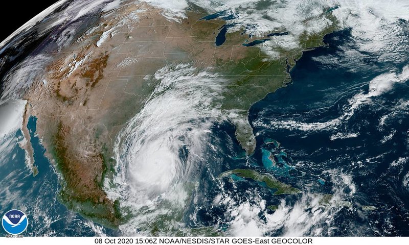
At 1000 AM CDT (1500 UTC), the center of Hurricane Delta was located
near latitude 24.0 North, longitude 92.7 West. Delta is moving
toward the northwest near 14 mph (22 km/h), and this motion with a
reduction in forward speed is expected today. A turn toward the
north is forecast to occur by late tonight, followed by a north-
northeastward motion by Friday afternoon or Friday night. On the
forecast track, the center of Delta will move over the central Gulf
of Mexico today, over the northwestern Gulf of Mexico on Friday,
and then move inland within the hurricane warning area Friday
afternoon or Friday night.
Reports from NOAA and Air Force Reserve Hurricane Hunter aircraft
indicate that maximum sustained winds have increased to near 105
mph (165 km/h) with higher gusts. Additional strengthening is
forecast, and Delta is expected to become a major hurricane again
by tonight. Some weakening is possible as Delta approaches the
northern Gulf coast on Friday, with rapid weakening expected after
the center moves inland.
Hurricane-force winds extend outward up to 35 miles (55 km) from the
center and tropical-storm-force winds extend outward up to 125 miles
(205 km).
The latest minimum central pressure reported by the Hurricane
Hunter aircraft is 968 mb (28.59 inches).
HAZARDS AFFECTING LAND
----------------------
Key messages for Delta can be found in the Tropical Cyclone
Discussion under AWIPS header MIATCDAT1, WMO header WTNT41
KNHC, and on the web at http://www.hurricanes.gov/text/MIATCDAT1.shtml.
STORM SURGE: The combination of a dangerous storm surge and the
tide will cause normally dry areas near the coast to be flooded by
rising waters moving inland from the shoreline. The water could
reach the following heights above ground somewhere in the indicated
areas if the peak surge occurs at the time of high tide...
Rockefeller Wildlife Refuge, LA to Port Fourchon, LA including
Vermilion Bay...7-11 ft
Holly Beach, LA to Rockefeller Wildlife Refuge, LA...4-7 ft
Port Fourchon, LA to the Mouth of the Mississippi River...4-6 ft
Sabine Pass to Holly Beach, LA...3-5 ft
Calcasieu Lake...3-5 ft
High Island, TX to Sabine Pass...2-4 ft
Mouth of the Mississippi River to Ocean Springs, MS...2-4 ft
Lake Borgne, Lake Pontchartrain, and Lake Maurepas...2-4 ft
Ocean Springs, MS to the AL/FL border including Mobile Bay...1-3 ft
Sabine Lake...1-3 ft
Port O'Connor, TX to High Island, TX including Galveston Bay...
1-3 ft
The deepest water will occur along the immediate coast near and to
the east of the landfall location, where the surge will be
accompanied by large and dangerous waves. Surge-related flooding
depends on the relative timing of the surge and the tidal cycle,
and can vary greatly over short distances. For information
specific to your area, please see products issued by your local
National Weather Service forecast office.
WIND: Hurricane conditions are expected within the hurricane
warning area by Friday afternoon or evening, with tropical storm
conditions expected within this area by early Friday. Tropical
storm conditions are expected within the tropical storm warning
areas on Friday, and are possible in the tropical storm watch area
Friday night.
RAINFALL: Friday through Saturday, Delta is expected to produce 5
to 10 inches of rain, with isolated maximum totals of 15 inches,
from southwest into south-central Louisiana. These rainfall amounts
will lead to significant flash, urban, small stream flooding, along
with minor to isolated moderate river flooding.
For extreme east Texas into northern Louisiana, southern Arkansas
and western Mississippi, Delta is expected to produce 3 to 6 inches
of rain, with isolated maximum totals of 10 inches. These rainfall
amounts will lead to flash, urban, small stream and isolated minor
river flooding.
As Delta moves farther inland, 1 to 3 inches of rain, with locally
higher amounts, are expected in the Ohio Valley and Mid Atlantic
this weekend.
TORNADOES: A few tornadoes are possible late tonight through Friday
over southern parts of Louisiana and Mississippi
SURF: Swells from Delta will begin to affect portions of the
northern and western Gulf coast later today. These swells are likely
to cause life-threatening surf and rip current conditions. Please
consult products from your local weather office.
NEXT ADVISORY
-------------
Next intermediate advisory at 100 PM CDT.
Next complete advisory at 400 PM CDT.
===============================================
HURRICANE DELTA FORECAST/ADVISORY NUMBER 16
NWS NATIONAL HURRICANE CENTER MIAMI FL AL [login to see] UTC THU OCT 08 2020
CHANGES IN WATCHES AND WARNINGS WITH THIS ADVISORY...
A STORM SURGE WARNING IS NOW IN EFFECT FOR THE TEXAS COAST FROM
HIGH ISLAND TO SABINE PASS.
A HURRICANE WARNING IS NOW IN EFFECT FOR THE TEXAS COAST FROM HIGH
ISLAND TO SABINE PASS.
SUMMARY OF WATCHES AND WARNINGS IN EFFECT...
A STORM SURGE WARNING IS IN EFFECT FOR...
* HIGH ISLAND TEXAS TO OCEAN SPRINGS MISSISSIPPI INCLUDING
CALCASIEU LAKE...VERMILION BAY...LAKE PONTCHARTRAIN...LAKE
MAUREPAS...AND LAKE BORGNE
A HURRICANE WARNING IS IN EFFECT FOR...
* HIGH ISLAND TEXAS TO MORGAN CITY LOUISIANA
A TROPICAL STORM WARNING IS IN EFFECT FOR...
* WEST OF HIGH ISLAND TO SAN LUIS PASS TEXAS
* EAST OF MORGAN CITY LOUISIANA TO THE MOUTH OF THE PEARL RIVER...
INCLUDING NEW ORLEANS
* LAKE PONTCHARTRAIN AND LAKE MAUREPAS
A TROPICAL STORM WATCH IS IN EFFECT FOR...
* EAST OF THE MOUTH OF THE PEARL RIVER TO BAY ST. LOUIS MISSISSIPPI
A STORM SURGE WARNING MEANS THERE IS A DANGER OF LIFE-THREATENING
INUNDATION...FROM RISING WATER MOVING INLAND FROM THE COASTLINE...
DURING THE NEXT 36 HOURS IN THE INDICATED LOCATIONS. FOR A
DEPICTION OF AREAS AT RISK...PLEASE SEE THE NATIONAL WEATHER
SERVICE STORM SURGE WATCH/WARNING GRAPHIC...AVAILABLE AT
HURRICANES.GOV. THIS IS A LIFE-THREATENING SITUATION. PERSONS
LOCATED WITHIN THESE AREAS SHOULD TAKE ALL NECESSARY ACTIONS TO
PROTECT LIFE AND PROPERTY FROM RISING WATER AND THE POTENTIAL FOR
OTHER DANGEROUS CONDITIONS. PROMPTLY FOLLOW EVACUATION AND OTHER
INSTRUCTIONS FROM LOCAL OFFICIALS.
A HURRICANE WARNING MEANS THAT HURRICANE CONDITIONS ARE EXPECTED
SOMEWHERE WITHIN THE WARNING AREA. A WARNING IS TYPICALLY ISSUED
36 HOURS BEFORE THE ANTICIPATED FIRST OCCURRENCE OF
TROPICAL-STORM-FORCE WINDS...CONDITIONS THAT MAKE OUTSIDE
PREPARATIONS DIFFICULT OR DANGEROUS. PREPARATIONS TO PROTECT LIFE
AND PROPERTY SHOULD BE RUSHED TO COMPLETION.
A TROPICAL STORM WARNING MEANS THAT TROPICAL STORM CONDITIONS ARE
EXPECTED SOMEWHERE WITHIN THE WARNING AREA.
A TROPICAL STORM WATCH MEANS THAT TROPICAL STORM CONDITIONS ARE
POSSIBLE WITHIN THE WATCH AREA.
HURRICANE CENTER LOCATED NEAR 24.0N 92.7W AT 08/1500Z
POSITION ACCURATE WITHIN 20 NM
PRESENT MOVEMENT TOWARD THE NORTHWEST OR 310 DEGREES AT 12 KT
ESTIMATED MINIMUM CENTRAL PRESSURE 968 MB
EYE DIAMETER 35 NM
MAX SUSTAINED WINDS 90 KT WITH GUSTS TO 110 KT.
64 KT....... 30NE 25SE 20SW 25NW.
50 KT....... 50NE 40SE 40SW 50NW.
34 KT.......110NE 90SE 60SW 100NW.
12 FT SEAS..270NE 90SE 90SW 180NW.
WINDS AND SEAS VARY GREATLY IN EACH QUADRANT. RADII IN NAUTICAL
MILES ARE THE LARGEST RADII EXPECTED ANYWHERE IN THAT QUADRANT.
REPEAT...CENTER LOCATED NEAR 24.0N 92.7W AT 08/1500Z
AT 08/1200Z CENTER WAS LOCATED NEAR 23.7N 92.4W
FORECAST VALID 09/0000Z 25.4N 93.6W
MAX WIND 95 KT...GUSTS 115 KT.
64 KT... 30NE 25SE 20SW 25NW.
50 KT... 60NE 40SE 40SW 50NW.
34 KT...120NE 100SE 80SW 120NW.
FORECAST VALID 09/1200Z 27.5N 93.8W
MAX WIND 100 KT...GUSTS 120 KT.
64 KT... 35NE 30SE 20SW 30NW.
50 KT... 60NE 50SE 40SW 50NW.
34 KT...140NE 130SE 100SW 110NW.
FORECAST VALID 10/0000Z 29.8N 93.1W...ON THE COAST
MAX WIND 90 KT...GUSTS 110 KT.
64 KT... 30NE 30SE 25SW 30NW.
50 KT... 60NE 60SE 40SW 50NW.
34 KT...130NE 140SE 100SW 90NW.
FORECAST VALID 10/1200Z 32.4N 91.7W...INLAND
MAX WIND 45 KT...GUSTS 55 KT.
34 KT... 40NE 80SE 40SW 30NW.
FORECAST VALID 11/0000Z 34.0N 90.0W...INLAND
MAX WIND 30 KT...GUSTS 40 KT.
FORECAST VALID 11/1200Z 35.6N 87.9W...POST-TROP/REMNT LOW
MAX WIND 20 KT...GUSTS 30 KT.
EXTENDED OUTLOOK. NOTE...ERRORS FOR TRACK HAVE AVERAGED NEAR 150 NM
ON DAY 4 AND 175 NM ON DAY 5...AND FOR INTENSITY NEAR 15 KT EACH DAY
OUTLOOK VALID 12/1200Z...DISSIPATED
REQUEST FOR 3 HOURLY SHIP REPORTS WITHIN 300 MILES OF 24.0N 92.7W
INTERMEDIATE PUBLIC ADVISORY...WTNT31 KNHC/MIATCPAT1...AT 08/1800Z
NEXT ADVISORY AT 08/2100Z
========================================
Hurricane Delta Discussion Number 16
NWS National Hurricane Center Miami FL AL [login to see] AM CDT Thu Oct 08 2020
Satellite imagery shows that Delta is better organized this
morning, with the center well embedded in a cold central dense
overcast and a hint of a eye developing in the overcast. Reports
from Air Force Reserve and NOAA Hurricane hunter aircraft indicate
that the central pressure has fallen to 968 mb inside a 35 n mi wide
eye, along with flight-level and SFMR winds that support an initial
intensity of 90 kt.
The initial motion remains northwestward or 305/12 kt. The track
forecast is reasonably straightforward. During the next 12-24 h,
Delta should turn to the north between a mid- to upper-level ridge
over the Florida Peninsula and eastern Gulf of Mexico and a mid- to
upper-level level trough over the U.S. Southern Plains. This
should be followed by a north-northeastward motion that is expected
to bring the center near or over the northern Gulf coast, most
likely in southwestern Louisiana, in about 36 h. After landfall,
the cyclone should move northeastward through the Lower Mississippi
and Tennessee Valleys along the southern edge of the mid-latitude
westerlies until it dissipates. The track guidance is very tightly
clustered in terms of direction, and the new forecast track has
only minor tweaks from the previous one.
Shear, sea surface temperature, and moisture conditions appear
favorable for strengthening during the next 12-24 h or so, and
based on this Delta is expected to regain major hurricane strength.
Rapid intensification cannot be ruled out, although the various
rapid intensification indices do not suggest a high chance, and
the first 24 h of the forecast is already above the intensity
guidance. The global models forecast strong southwesterly shear
developing over the hurricane during the last 12 h before landfall,
and based on this some weakening is forecast. Rapid weakening is
expected after landfall, with Delta forecast to degenerate to a
remnant low by 72 h and dissipate shortly after that. It should be
noted that the NHC 1-2 day intensity forecasts are subject to errors
of around 1 Saffir-Simpson category.
Delta is expected to grow in size as it approaches the Louisiana
coast. The NHC wind radii forecast again follows a consensus of the
global and hurricane regional models.
Key Messages:
1. Life-threatening storm surge is expected near and east of where
Delta makes landfall on Friday, and a Storm Surge Warning is in
effect from High Island, Texas, to Ocean Springs, Mississippi. The
highest inundation of 7 to 11 feet is expected somewhere between
Rockefeller Wildlife Refuge and Port Fourchon, Louisiana. Residents
in the warning area should promptly follow advice given by local
officials. The storm surge risk remains high despite the forecast
decrease in intensity before landfall since Delta is expected to
grow in size.
2. Hurricane-force winds are expected Friday afternoon and evening
somewhere within the Hurricane Warning area between High Island,
Texas, and Morgan City, Louisiana. Hurricane-force winds will also
spread inland across portions of southern Louisiana near the path of
Deltas center Friday evening and Friday night.
3. Significant flash flooding and minor to moderate river flooding
are likely in parts of Louisiana Friday and Saturday, with
additional flooding in portions of the central Gulf Coast into the
Lower Mississippi Valley.
FORECAST POSITIONS AND MAX WINDS
INIT 08/1500Z 24.0N 92.7W 90 KT 105 MPH
12H 09/0000Z 25.4N 93.6W 95 KT 110 MPH
24H 09/1200Z 27.5N 93.8W 100 KT 115 MPH
36H 10/0000Z 29.8N 93.1W 90 KT 105 MPH...ON THE COAST
48H 10/1200Z 32.4N 91.7W 45 KT 50 MPH...INLAND
60H 11/0000Z 34.0N 90.0W 30 KT 35 MPH...INLAND
72H 11/1200Z 35.6N 87.9W 20 KT 25 MPH...POST-TROP/REMNT LOW
96H 12/1200Z...DISSIPATED
=============================================
HURRICANE DELTA WIND SPEED PROBABILITIES NUMBER 16
NWS NATIONAL HURRICANE CENTER MIAMI FL AL262020
1500 UTC THU OCT 08 2020
AT 1500Z THE CENTER OF HURRICANE DELTA WAS LOCATED NEAR LATITUDE
24.0 NORTH...LONGITUDE 92.7 WEST WITH MAXIMUM SUSTAINED WINDS NEAR
90 KTS...105 MPH...165 KM/H.
Z INDICATES COORDINATED UNIVERSAL TIME (GREENWICH)
ATLANTIC STANDARD TIME (AST)...SUBTRACT 4 HOURS FROM Z TIME
EASTERN DAYLIGHT TIME (EDT)...SUBTRACT 4 HOURS FROM Z TIME
CENTRAL DAYLIGHT TIME (CDT)...SUBTRACT 5 HOURS FROM Z TIME
WIND SPEED PROBABILITY TABLE FOR SPECIFIC LOCATIONS
CHANCES OF SUSTAINED (1-MINUTE AVERAGE) WIND SPEEDS OF AT LEAST
...34 KT (39 MPH... 63 KM/H)...
...50 KT (58 MPH... 93 KM/H)...
...64 KT (74 MPH...119 KM/H)...
FOR LOCATIONS AND TIME PERIODS DURING THE NEXT 5 DAYS
PROBABILITIES FOR LOCATIONS ARE GIVEN AS OP(CP) WHERE
OP IS THE PROBABILITY OF THE EVENT BEGINNING DURING
AN INDIVIDUAL TIME PERIOD (ONSET PROBABILITY)
(CP) IS THE PROBABILITY OF THE EVENT OCCURRING BETWEEN
12Z THU AND THE FORECAST HOUR (CUMULATIVE PROBABILITY)
PROBABILITIES ARE GIVEN IN PERCENT
X INDICATES PROBABILITIES LESS THAN 1 PERCENT
PROBABILITIES FOR 34 KT AND 50 KT ARE SHOWN AT A GIVEN LOCATION WHEN
THE 5-DAY CUMULATIVE PROBABILITY IS AT LEAST 3 PERCENT.
PROBABILITIES FOR 34...50...64 KT SHOWN WHEN THE 5-DAY
64-KT CUMULATIVE PROBABILITY IS AT LEAST 1 PERCENT.
- - - - WIND SPEED PROBABILITIES FOR SELECTED LOCATIONS - - - -
FROM FROM FROM FROM FROM FROM FROM
TIME 12Z THU 00Z FRI 12Z FRI 00Z SAT 12Z SAT 12Z SUN 12Z MON
PERIODS TO TO TO TO TO TO TO
00Z FRI 12Z FRI 00Z SAT 12Z SAT 12Z SUN 12Z MON 12Z TUE
FORECAST HOUR (12) (24) (36) (48) (72) (96) (120)
- - - - - - - - - - - - - - - - - - - - - - - - - - - - - - - - - -
LOCATION KT
DESTIN EXEC AP 34 X X( X) 1( 1) 2( 3) 1( 4) X( 4) X( 4)
BIRMINGHAM AL 34 X X( X) X( X) 3( 3) 2( 5) X( 5) X( 5)
MONTGOMERY AL 34 X X( X) X( X) 3( 3) 1( 4) X( 4) X( 4)
WHITING FLD FL 34 X X( X) 2( 2) 3( 5) X( 5) X( 5) X( 5)
PENSACOLA FL 34 X X( X) 2( 2) 4( 6) X( 6) X( 6) X( 6)
GFMX 290N 870W 34 X X( X) 2( 2) 1( 3) X( 3) X( 3) X( 3)
MOBILE AL 34 X X( X) 6( 6) 8(14) X(14) X(14) X(14)
GULFPORT MS 34 X 1( 1) 12(13) 11(24) X(24) X(24) X(24)
STENNIS MS 34 X 2( 2) 17(19) 16(35) X(35) X(35) X(35)
STENNIS MS 50 X X( X) 1( 1) 2( 3) X( 3) X( 3) X( 3)
BURAS LA 34 X 4( 4) 14(18) 10(28) X(28) X(28) X(28)
GFMX 280N 890W 34 1 5( 6) 5(11) 2(13) X(13) X(13) X(13)
JACKSON MS 34 X X( X) 14(14) 31(45) 2(47) X(47) X(47)
JACKSON MS 50 X X( X) 1( 1) 7( 8) X( 8) X( 8) X( 8)
JACKSON MS 64 X X( X) X( X) 1( 1) X( 1) X( 1) X( 1)
NEW ORLEANS LA 34 X 4( 4) 33(37) 14(51) X(51) X(51) X(51)
NEW ORLEANS LA 50 X X( X) 3( 3) 4( 7) X( 7) X( 7) X( 7)
NEW ORLEANS LA 64 X X( X) 1( 1) 1( 2) X( 2) X( 2) X( 2)
GFMX 280N 910W 34 4 27(31) 20(51) 1(52) X(52) X(52) X(52)
GFMX 280N 910W 50 X 3( 3) 4( 7) X( 7) X( 7) X( 7) X( 7)
GFMX 280N 910W 64 X X( X) 1( 1) X( 1) X( 1) X( 1) X( 1)
BATON ROUGE LA 34 X 4( 4) 54(58) 17(75) 1(76) X(76) X(76)
BATON ROUGE LA 50 X X( X) 16(16) 16(32) X(32) X(32) X(32)
BATON ROUGE LA 64 X X( X) 3( 3) 8(11) X(11) X(11) X(11)
MORGAN CITY LA 34 1 5( 6) 57(63) 11(74) X(74) X(74) X(74)
MORGAN CITY LA 50 X X( X) 18(18) 7(25) X(25) X(25) X(25)
MORGAN CITY LA 64 X X( X) 4( 4) 3( 7) X( 7) X( 7) X( 7)
ALEXANDRIA LA 34 X 3( 3) 55(58) 28(86) 1(87) X(87) X(87)
ALEXANDRIA LA 50 X X( X) 24(24) 31(55) X(55) X(55) X(55)
ALEXANDRIA LA 64 X X( X) 8( 8) 20(28) X(28) X(28) X(28)
LAFAYETTE LA 34 1 5( 6) 74(80) 11(91) 1(92) X(92) X(92)
LAFAYETTE LA 50 X X( X) 42(42) 19(61) X(61) X(61) X(61)
LAFAYETTE LA 64 X X( X) 21(21) 15(36) X(36) X(36) X(36)
NEW IBERIA LA 34 1 6( 7) 74(81) 9(90) X(90) X(90) X(90)
NEW IBERIA LA 50 X 1( 1) 40(41) 14(55) X(55) X(55) X(55)
NEW IBERIA LA 64 X X( X) 19(19) 9(28) X(28) X(28) X(28)
GFMX 280N 930W 34 7 88(95) 4(99) X(99) X(99) X(99) X(99)
GFMX 280N 930W 50 1 59(60) 22(82) X(82) X(82) X(82) X(82)
GFMX 280N 930W 64 X 25(25) 29(54) X(54) X(54) X(54) X(54)
SHREVEPORT LA 34 X 1( 1) 19(20) 13(33) 1(34) X(34) X(34)
SHREVEPORT LA 50 X X( X) 2( 2) 3( 5) 1( 6) X( 6) X( 6)
FORT POLK LA 34 X 4( 4) 62(66) 17(83) 1(84) X(84) X(84)
FORT POLK LA 50 X X( X) 32(32) 20(52) 1(53) X(53) X(53)
FORT POLK LA 64 X X( X) 12(12) 12(24) X(24) X(24) X(24)
LAKE CHARLES 34 1 9(10) 77(87) 6(93) X(93) X(93) X(93)
LAKE CHARLES 50 X 1( 1) 59(60) 15(75) X(75) X(75) X(75)
LAKE CHARLES 64 X X( X) 32(32) 15(47) X(47) X(47) X(47)
CAMERON LA 34 2 37(39) 57(96) 1(97) X(97) X(97) X(97)
CAMERON LA 50 X 4( 4) 75(79) 4(83) X(83) X(83) X(83)
CAMERON LA 64 X 1( 1) 52(53) 6(59) 1(60) X(60) X(60)
JASPER TX 34 X 4( 4) 55(59) 12(71) X(71) X(71) X(71)
JASPER TX 50 X X( X) 21(21) 8(29) X(29) X(29) X(29)
JASPER TX 64 X X( X) 7( 7) 3(10) X(10) X(10) X(10)
KOUNTZE TX 34 1 6( 7) 59(66) 6(72) X(72) X(72) X(72)
KOUNTZE TX 50 X 1( 1) 24(25) 6(31) X(31) X(31) X(31)
KOUNTZE TX 64 X X( X) 8( 8) 3(11) X(11) X(11) X(11)
PORT ARTHUR TX 34 2 11(13) 68(81) 3(84) X(84) X(84) X(84)
PORT ARTHUR TX 50 X 2( 2) 43(45) 5(50) 1(51) X(51) X(51)
PORT ARTHUR TX 64 X X( X) 20(20) 6(26) X(26) X(26) X(26)
GALVESTON TX 34 3 41(44) 32(76) 1(77) X(77) X(77) X(77)
GALVESTON TX 50 X 6( 6) 24(30) 1(31) X(31) X(31) X(31)
GALVESTON TX 64 X 1( 1) 9(10) X(10) 1(11) X(11) X(11)
HOUSTON TX 34 1 7( 8) 25(33) 3(36) 1(37) X(37) X(37)
HOUSTON TX 50 X 1( 1) 7( 8) X( 8) 1( 9) X( 9) X( 9)
HOUSTON TX 64 X X( X) 2( 2) X( 2) X( 2) X( 2) X( 2)
AUSTIN TX 34 X 2( 2) 3( 5) X( 5) X( 5) X( 5) X( 5)
SAN ANTONIO TX 34 X 2( 2) 2( 4) X( 4) X( 4) X( 4) X( 4)
FREEPORT TX 34 2 17(19) 19(38) 1(39) X(39) X(39) X(39)
FREEPORT TX 50 X 3( 3) 5( 8) X( 8) X( 8) X( 8) X( 8)
FREEPORT TX 64 X X( X) 2( 2) X( 2) X( 2) X( 2) X( 2)
GFMX 280N 950W 34 5 73(78) 3(81) 1(82) X(82) X(82) X(82)
GFMX 280N 950W 50 1 29(30) 8(38) X(38) X(38) X(38) X(38)
GFMX 280N 950W 64 X 8( 8) 4(12) X(12) X(12) X(12) X(12)
HIGH ISLAND TX 34 2 22(24) 52(76) 1(77) X(77) X(77) X(77)
HIGH ISLAND TX 50 X 3( 3) 29(32) 2(34) 1(35) X(35) X(35)
HIGH ISLAND TX 64 X 1( 1) 12(13) 2(15) X(15) X(15) X(15)
MATAGORDA TX 34 3 22(25) 10(35) X(35) X(35) X(35) X(35)
MATAGORDA TX 50 X 3( 3) 2( 5) X( 5) X( 5) X( 5) X( 5)
PORT O CONNOR 34 3 13(16) 6(22) X(22) X(22) X(22) X(22)
ROCKPORT TX 34 2 3( 5) 2( 7) 1( 8) X( 8) X( 8) X( 8)
CORPUS CHRISTI 34 2 2( 4) 2( 6) X( 6) X( 6) X( 6) X( 6)
GFMX 270N 960W 34 5 26(31) 1(32) 1(33) X(33) X(33) X(33)
GFMX 270N 960W 50 1 4( 5) X( 5) X( 5) X( 5) X( 5) X( 5)
MCALLEN TX 34 2 2( 4) X( 4) X( 4) X( 4) X( 4) X( 4)
HARLINGEN TX 34 2 2( 4) 1( 5) X( 5) X( 5) X( 5) X( 5)
BROWNSVILLE TX 34 2 2( 4) 1( 5) X( 5) X( 5) X( 5) X( 5)
GFMX 250N 960W 34 6 3( 9) 2(11) X(11) X(11) X(11) X(11)
GFMX 250N 960W 50 2 1( 3) X( 3) X( 3) X( 3) X( 3) X( 3)
PENSACOLA NAS 34 X X( X) 3( 3) 3( 6) 1( 7) X( 7) X( 7)
KEESLER AB 34 X 2( 2) 11(13) 9(22) X(22) X(22) X(22)
=============================================
================================================
REMEMBER: THE EYE MATERS OF COURSE, BUT THE HIGH WINDS,
STORM SURGE, HEAVY RAIN, ETC PRECEDES THE EYE. THE LOWER
THE PRESSURE THE MORE INTENSE A STORM WILL BE.
AREAS OF LOW PRESSURE ARE LIKE LITTLE DIVOTS OR
THE GRAVITY FIELD. STORMS FOLLOW THE PATH OF
LEAST RESISTANCE. IN OTHER WORDS THERE ARE SO
MANY VARIABLES BUT THERE A FEW RULES OF THUMB
MAKE IT A BIT EASIER TO ESTIMATE, WHEN, WHERE
AND HOW THESE THINGS WORK.
BULLETIN
Hurricane Delta Advisory Number 16
NWS National Hurricane Center Miami FL AL [login to see] AM CDT Thu Oct 08 2020
...NOAA AND AIR FORCE RESERVE HURRICANE HUNTERS REPORT DELTA HAS
STRENGTHENED...
...HURRICANE CONDITIONS AND LIFE-THREATENING STORM SURGE EXPECTED
TO BEGIN ALONG PORTIONS OF THE NORTHERN GULF COAST ON FRIDAY...
SUMMARY OF 1000 AM CDT...1500 UTC...INFORMATION
-----------------------------------------------
LOCATION...24.0N 92.7W
ABOUT 400 MI...645 KM S OF CAMERON LOUISIANA
MAXIMUM SUSTAINED WINDS...105 MPH...165 KM/H
PRESENT MOVEMENT...NW OR 310 DEGREES AT 14 MPH...22 KM/H
MINIMUM CENTRAL PRESSURE...968 MB...28.59 INCHES
WATCHES AND WARNINGS
--------------------
CHANGES WITH THIS ADVISORY:
A Storm Surge Warning is now in effect for the Texas coast from
High Island to Sabine Pass.
A Hurricane Warning is now in effect for the Texas coast from High
Island to Sabine Pass.
SUMMARY OF WATCHES AND WARNINGS IN EFFECT:
A Storm Surge Warning is in effect for...
* High Island Texas to Ocean Springs Mississippi including
Calcasieu Lake, Vermilion Bay, Lake Pontchartrain, Lake Maurepas,
and Lake Borgne
A Hurricane Warning is in effect for...
* High Island Texas to Morgan City Louisiana
A Tropical Storm Warning is in effect for...
* West of High Island to San Luis Pass Texas
* East of Morgan City Louisiana to the mouth of the Pearl River,
including New Orleans
* Lake Pontchartrain and Lake Maurepas
A Tropical Storm Watch is in effect for...
* East of the mouth of the Pearl River to Bay St. Louis Mississippi
A Storm Surge Warning means there is a danger of life-threatening
inundation, from rising water moving inland from the coastline,
during the next 36 hours in the indicated locations. For a
depiction of areas at risk, please see the National Weather
Service Storm Surge Watch/Warning Graphic, available at
hurricanes.gov. This is a life-threatening situation. Persons
located within these areas should take all necessary actions to
protect life and property from rising water and the potential for
other dangerous conditions. Promptly follow evacuation and other
instructions from local officials.
A Hurricane Warning means that hurricane conditions are expected
somewhere within the warning area. A warning is typically issued
36 hours before the anticipated first occurrence of
tropical-storm-force winds, conditions that make outside
preparations difficult or dangerous. Preparations to protect life
and property should be rushed to completion.
A Tropical Storm Warning means that tropical storm conditions are
expected somewhere within the warning area.
A Tropical Storm Watch means that tropical storm conditions are
possible within the watch area.
For storm information specific to your area, including possible
inland watches and warnings, please monitor products issued by your
local National Weather Service forecast office.
DISCUSSION AND OUTLOOK
----------------------
At 1000 AM CDT (1500 UTC), the center of Hurricane Delta was located
near latitude 24.0 North, longitude 92.7 West. Delta is moving
toward the northwest near 14 mph (22 km/h), and this motion with a
reduction in forward speed is expected today. A turn toward the
north is forecast to occur by late tonight, followed by a north-
northeastward motion by Friday afternoon or Friday night. On the
forecast track, the center of Delta will move over the central Gulf
of Mexico today, over the northwestern Gulf of Mexico on Friday,
and then move inland within the hurricane warning area Friday
afternoon or Friday night.
Reports from NOAA and Air Force Reserve Hurricane Hunter aircraft
indicate that maximum sustained winds have increased to near 105
mph (165 km/h) with higher gusts. Additional strengthening is
forecast, and Delta is expected to become a major hurricane again
by tonight. Some weakening is possible as Delta approaches the
northern Gulf coast on Friday, with rapid weakening expected after
the center moves inland.
Hurricane-force winds extend outward up to 35 miles (55 km) from the
center and tropical-storm-force winds extend outward up to 125 miles
(205 km).
The latest minimum central pressure reported by the Hurricane
Hunter aircraft is 968 mb (28.59 inches).
HAZARDS AFFECTING LAND
----------------------
Key messages for Delta can be found in the Tropical Cyclone
Discussion under AWIPS header MIATCDAT1, WMO header WTNT41
KNHC, and on the web at http://www.hurricanes.gov/text/MIATCDAT1.shtml.
STORM SURGE: The combination of a dangerous storm surge and the
tide will cause normally dry areas near the coast to be flooded by
rising waters moving inland from the shoreline. The water could
reach the following heights above ground somewhere in the indicated
areas if the peak surge occurs at the time of high tide...
Rockefeller Wildlife Refuge, LA to Port Fourchon, LA including
Vermilion Bay...7-11 ft
Holly Beach, LA to Rockefeller Wildlife Refuge, LA...4-7 ft
Port Fourchon, LA to the Mouth of the Mississippi River...4-6 ft
Sabine Pass to Holly Beach, LA...3-5 ft
Calcasieu Lake...3-5 ft
High Island, TX to Sabine Pass...2-4 ft
Mouth of the Mississippi River to Ocean Springs, MS...2-4 ft
Lake Borgne, Lake Pontchartrain, and Lake Maurepas...2-4 ft
Ocean Springs, MS to the AL/FL border including Mobile Bay...1-3 ft
Sabine Lake...1-3 ft
Port O'Connor, TX to High Island, TX including Galveston Bay...
1-3 ft
The deepest water will occur along the immediate coast near and to
the east of the landfall location, where the surge will be
accompanied by large and dangerous waves. Surge-related flooding
depends on the relative timing of the surge and the tidal cycle,
and can vary greatly over short distances. For information
specific to your area, please see products issued by your local
National Weather Service forecast office.
WIND: Hurricane conditions are expected within the hurricane
warning area by Friday afternoon or evening, with tropical storm
conditions expected within this area by early Friday. Tropical
storm conditions are expected within the tropical storm warning
areas on Friday, and are possible in the tropical storm watch area
Friday night.
RAINFALL: Friday through Saturday, Delta is expected to produce 5
to 10 inches of rain, with isolated maximum totals of 15 inches,
from southwest into south-central Louisiana. These rainfall amounts
will lead to significant flash, urban, small stream flooding, along
with minor to isolated moderate river flooding.
For extreme east Texas into northern Louisiana, southern Arkansas
and western Mississippi, Delta is expected to produce 3 to 6 inches
of rain, with isolated maximum totals of 10 inches. These rainfall
amounts will lead to flash, urban, small stream and isolated minor
river flooding.
As Delta moves farther inland, 1 to 3 inches of rain, with locally
higher amounts, are expected in the Ohio Valley and Mid Atlantic
this weekend.
TORNADOES: A few tornadoes are possible late tonight through Friday
over southern parts of Louisiana and Mississippi
SURF: Swells from Delta will begin to affect portions of the
northern and western Gulf coast later today. These swells are likely
to cause life-threatening surf and rip current conditions. Please
consult products from your local weather office.
NEXT ADVISORY
-------------
Next intermediate advisory at 100 PM CDT.
Next complete advisory at 400 PM CDT.
===============================================
HURRICANE DELTA FORECAST/ADVISORY NUMBER 16
NWS NATIONAL HURRICANE CENTER MIAMI FL AL [login to see] UTC THU OCT 08 2020
CHANGES IN WATCHES AND WARNINGS WITH THIS ADVISORY...
A STORM SURGE WARNING IS NOW IN EFFECT FOR THE TEXAS COAST FROM
HIGH ISLAND TO SABINE PASS.
A HURRICANE WARNING IS NOW IN EFFECT FOR THE TEXAS COAST FROM HIGH
ISLAND TO SABINE PASS.
SUMMARY OF WATCHES AND WARNINGS IN EFFECT...
A STORM SURGE WARNING IS IN EFFECT FOR...
* HIGH ISLAND TEXAS TO OCEAN SPRINGS MISSISSIPPI INCLUDING
CALCASIEU LAKE...VERMILION BAY...LAKE PONTCHARTRAIN...LAKE
MAUREPAS...AND LAKE BORGNE
A HURRICANE WARNING IS IN EFFECT FOR...
* HIGH ISLAND TEXAS TO MORGAN CITY LOUISIANA
A TROPICAL STORM WARNING IS IN EFFECT FOR...
* WEST OF HIGH ISLAND TO SAN LUIS PASS TEXAS
* EAST OF MORGAN CITY LOUISIANA TO THE MOUTH OF THE PEARL RIVER...
INCLUDING NEW ORLEANS
* LAKE PONTCHARTRAIN AND LAKE MAUREPAS
A TROPICAL STORM WATCH IS IN EFFECT FOR...
* EAST OF THE MOUTH OF THE PEARL RIVER TO BAY ST. LOUIS MISSISSIPPI
A STORM SURGE WARNING MEANS THERE IS A DANGER OF LIFE-THREATENING
INUNDATION...FROM RISING WATER MOVING INLAND FROM THE COASTLINE...
DURING THE NEXT 36 HOURS IN THE INDICATED LOCATIONS. FOR A
DEPICTION OF AREAS AT RISK...PLEASE SEE THE NATIONAL WEATHER
SERVICE STORM SURGE WATCH/WARNING GRAPHIC...AVAILABLE AT
HURRICANES.GOV. THIS IS A LIFE-THREATENING SITUATION. PERSONS
LOCATED WITHIN THESE AREAS SHOULD TAKE ALL NECESSARY ACTIONS TO
PROTECT LIFE AND PROPERTY FROM RISING WATER AND THE POTENTIAL FOR
OTHER DANGEROUS CONDITIONS. PROMPTLY FOLLOW EVACUATION AND OTHER
INSTRUCTIONS FROM LOCAL OFFICIALS.
A HURRICANE WARNING MEANS THAT HURRICANE CONDITIONS ARE EXPECTED
SOMEWHERE WITHIN THE WARNING AREA. A WARNING IS TYPICALLY ISSUED
36 HOURS BEFORE THE ANTICIPATED FIRST OCCURRENCE OF
TROPICAL-STORM-FORCE WINDS...CONDITIONS THAT MAKE OUTSIDE
PREPARATIONS DIFFICULT OR DANGEROUS. PREPARATIONS TO PROTECT LIFE
AND PROPERTY SHOULD BE RUSHED TO COMPLETION.
A TROPICAL STORM WARNING MEANS THAT TROPICAL STORM CONDITIONS ARE
EXPECTED SOMEWHERE WITHIN THE WARNING AREA.
A TROPICAL STORM WATCH MEANS THAT TROPICAL STORM CONDITIONS ARE
POSSIBLE WITHIN THE WATCH AREA.
HURRICANE CENTER LOCATED NEAR 24.0N 92.7W AT 08/1500Z
POSITION ACCURATE WITHIN 20 NM
PRESENT MOVEMENT TOWARD THE NORTHWEST OR 310 DEGREES AT 12 KT
ESTIMATED MINIMUM CENTRAL PRESSURE 968 MB
EYE DIAMETER 35 NM
MAX SUSTAINED WINDS 90 KT WITH GUSTS TO 110 KT.
64 KT....... 30NE 25SE 20SW 25NW.
50 KT....... 50NE 40SE 40SW 50NW.
34 KT.......110NE 90SE 60SW 100NW.
12 FT SEAS..270NE 90SE 90SW 180NW.
WINDS AND SEAS VARY GREATLY IN EACH QUADRANT. RADII IN NAUTICAL
MILES ARE THE LARGEST RADII EXPECTED ANYWHERE IN THAT QUADRANT.
REPEAT...CENTER LOCATED NEAR 24.0N 92.7W AT 08/1500Z
AT 08/1200Z CENTER WAS LOCATED NEAR 23.7N 92.4W
FORECAST VALID 09/0000Z 25.4N 93.6W
MAX WIND 95 KT...GUSTS 115 KT.
64 KT... 30NE 25SE 20SW 25NW.
50 KT... 60NE 40SE 40SW 50NW.
34 KT...120NE 100SE 80SW 120NW.
FORECAST VALID 09/1200Z 27.5N 93.8W
MAX WIND 100 KT...GUSTS 120 KT.
64 KT... 35NE 30SE 20SW 30NW.
50 KT... 60NE 50SE 40SW 50NW.
34 KT...140NE 130SE 100SW 110NW.
FORECAST VALID 10/0000Z 29.8N 93.1W...ON THE COAST
MAX WIND 90 KT...GUSTS 110 KT.
64 KT... 30NE 30SE 25SW 30NW.
50 KT... 60NE 60SE 40SW 50NW.
34 KT...130NE 140SE 100SW 90NW.
FORECAST VALID 10/1200Z 32.4N 91.7W...INLAND
MAX WIND 45 KT...GUSTS 55 KT.
34 KT... 40NE 80SE 40SW 30NW.
FORECAST VALID 11/0000Z 34.0N 90.0W...INLAND
MAX WIND 30 KT...GUSTS 40 KT.
FORECAST VALID 11/1200Z 35.6N 87.9W...POST-TROP/REMNT LOW
MAX WIND 20 KT...GUSTS 30 KT.
EXTENDED OUTLOOK. NOTE...ERRORS FOR TRACK HAVE AVERAGED NEAR 150 NM
ON DAY 4 AND 175 NM ON DAY 5...AND FOR INTENSITY NEAR 15 KT EACH DAY
OUTLOOK VALID 12/1200Z...DISSIPATED
REQUEST FOR 3 HOURLY SHIP REPORTS WITHIN 300 MILES OF 24.0N 92.7W
INTERMEDIATE PUBLIC ADVISORY...WTNT31 KNHC/MIATCPAT1...AT 08/1800Z
NEXT ADVISORY AT 08/2100Z
========================================
Hurricane Delta Discussion Number 16
NWS National Hurricane Center Miami FL AL [login to see] AM CDT Thu Oct 08 2020
Satellite imagery shows that Delta is better organized this
morning, with the center well embedded in a cold central dense
overcast and a hint of a eye developing in the overcast. Reports
from Air Force Reserve and NOAA Hurricane hunter aircraft indicate
that the central pressure has fallen to 968 mb inside a 35 n mi wide
eye, along with flight-level and SFMR winds that support an initial
intensity of 90 kt.
The initial motion remains northwestward or 305/12 kt. The track
forecast is reasonably straightforward. During the next 12-24 h,
Delta should turn to the north between a mid- to upper-level ridge
over the Florida Peninsula and eastern Gulf of Mexico and a mid- to
upper-level level trough over the U.S. Southern Plains. This
should be followed by a north-northeastward motion that is expected
to bring the center near or over the northern Gulf coast, most
likely in southwestern Louisiana, in about 36 h. After landfall,
the cyclone should move northeastward through the Lower Mississippi
and Tennessee Valleys along the southern edge of the mid-latitude
westerlies until it dissipates. The track guidance is very tightly
clustered in terms of direction, and the new forecast track has
only minor tweaks from the previous one.
Shear, sea surface temperature, and moisture conditions appear
favorable for strengthening during the next 12-24 h or so, and
based on this Delta is expected to regain major hurricane strength.
Rapid intensification cannot be ruled out, although the various
rapid intensification indices do not suggest a high chance, and
the first 24 h of the forecast is already above the intensity
guidance. The global models forecast strong southwesterly shear
developing over the hurricane during the last 12 h before landfall,
and based on this some weakening is forecast. Rapid weakening is
expected after landfall, with Delta forecast to degenerate to a
remnant low by 72 h and dissipate shortly after that. It should be
noted that the NHC 1-2 day intensity forecasts are subject to errors
of around 1 Saffir-Simpson category.
Delta is expected to grow in size as it approaches the Louisiana
coast. The NHC wind radii forecast again follows a consensus of the
global and hurricane regional models.
Key Messages:
1. Life-threatening storm surge is expected near and east of where
Delta makes landfall on Friday, and a Storm Surge Warning is in
effect from High Island, Texas, to Ocean Springs, Mississippi. The
highest inundation of 7 to 11 feet is expected somewhere between
Rockefeller Wildlife Refuge and Port Fourchon, Louisiana. Residents
in the warning area should promptly follow advice given by local
officials. The storm surge risk remains high despite the forecast
decrease in intensity before landfall since Delta is expected to
grow in size.
2. Hurricane-force winds are expected Friday afternoon and evening
somewhere within the Hurricane Warning area between High Island,
Texas, and Morgan City, Louisiana. Hurricane-force winds will also
spread inland across portions of southern Louisiana near the path of
Deltas center Friday evening and Friday night.
3. Significant flash flooding and minor to moderate river flooding
are likely in parts of Louisiana Friday and Saturday, with
additional flooding in portions of the central Gulf Coast into the
Lower Mississippi Valley.
FORECAST POSITIONS AND MAX WINDS
INIT 08/1500Z 24.0N 92.7W 90 KT 105 MPH
12H 09/0000Z 25.4N 93.6W 95 KT 110 MPH
24H 09/1200Z 27.5N 93.8W 100 KT 115 MPH
36H 10/0000Z 29.8N 93.1W 90 KT 105 MPH...ON THE COAST
48H 10/1200Z 32.4N 91.7W 45 KT 50 MPH...INLAND
60H 11/0000Z 34.0N 90.0W 30 KT 35 MPH...INLAND
72H 11/1200Z 35.6N 87.9W 20 KT 25 MPH...POST-TROP/REMNT LOW
96H 12/1200Z...DISSIPATED
=============================================
HURRICANE DELTA WIND SPEED PROBABILITIES NUMBER 16
NWS NATIONAL HURRICANE CENTER MIAMI FL AL262020
1500 UTC THU OCT 08 2020
AT 1500Z THE CENTER OF HURRICANE DELTA WAS LOCATED NEAR LATITUDE
24.0 NORTH...LONGITUDE 92.7 WEST WITH MAXIMUM SUSTAINED WINDS NEAR
90 KTS...105 MPH...165 KM/H.
Z INDICATES COORDINATED UNIVERSAL TIME (GREENWICH)
ATLANTIC STANDARD TIME (AST)...SUBTRACT 4 HOURS FROM Z TIME
EASTERN DAYLIGHT TIME (EDT)...SUBTRACT 4 HOURS FROM Z TIME
CENTRAL DAYLIGHT TIME (CDT)...SUBTRACT 5 HOURS FROM Z TIME
WIND SPEED PROBABILITY TABLE FOR SPECIFIC LOCATIONS
CHANCES OF SUSTAINED (1-MINUTE AVERAGE) WIND SPEEDS OF AT LEAST
...34 KT (39 MPH... 63 KM/H)...
...50 KT (58 MPH... 93 KM/H)...
...64 KT (74 MPH...119 KM/H)...
FOR LOCATIONS AND TIME PERIODS DURING THE NEXT 5 DAYS
PROBABILITIES FOR LOCATIONS ARE GIVEN AS OP(CP) WHERE
OP IS THE PROBABILITY OF THE EVENT BEGINNING DURING
AN INDIVIDUAL TIME PERIOD (ONSET PROBABILITY)
(CP) IS THE PROBABILITY OF THE EVENT OCCURRING BETWEEN
12Z THU AND THE FORECAST HOUR (CUMULATIVE PROBABILITY)
PROBABILITIES ARE GIVEN IN PERCENT
X INDICATES PROBABILITIES LESS THAN 1 PERCENT
PROBABILITIES FOR 34 KT AND 50 KT ARE SHOWN AT A GIVEN LOCATION WHEN
THE 5-DAY CUMULATIVE PROBABILITY IS AT LEAST 3 PERCENT.
PROBABILITIES FOR 34...50...64 KT SHOWN WHEN THE 5-DAY
64-KT CUMULATIVE PROBABILITY IS AT LEAST 1 PERCENT.
- - - - WIND SPEED PROBABILITIES FOR SELECTED LOCATIONS - - - -
FROM FROM FROM FROM FROM FROM FROM
TIME 12Z THU 00Z FRI 12Z FRI 00Z SAT 12Z SAT 12Z SUN 12Z MON
PERIODS TO TO TO TO TO TO TO
00Z FRI 12Z FRI 00Z SAT 12Z SAT 12Z SUN 12Z MON 12Z TUE
FORECAST HOUR (12) (24) (36) (48) (72) (96) (120)
- - - - - - - - - - - - - - - - - - - - - - - - - - - - - - - - - -
LOCATION KT
DESTIN EXEC AP 34 X X( X) 1( 1) 2( 3) 1( 4) X( 4) X( 4)
BIRMINGHAM AL 34 X X( X) X( X) 3( 3) 2( 5) X( 5) X( 5)
MONTGOMERY AL 34 X X( X) X( X) 3( 3) 1( 4) X( 4) X( 4)
WHITING FLD FL 34 X X( X) 2( 2) 3( 5) X( 5) X( 5) X( 5)
PENSACOLA FL 34 X X( X) 2( 2) 4( 6) X( 6) X( 6) X( 6)
GFMX 290N 870W 34 X X( X) 2( 2) 1( 3) X( 3) X( 3) X( 3)
MOBILE AL 34 X X( X) 6( 6) 8(14) X(14) X(14) X(14)
GULFPORT MS 34 X 1( 1) 12(13) 11(24) X(24) X(24) X(24)
STENNIS MS 34 X 2( 2) 17(19) 16(35) X(35) X(35) X(35)
STENNIS MS 50 X X( X) 1( 1) 2( 3) X( 3) X( 3) X( 3)
BURAS LA 34 X 4( 4) 14(18) 10(28) X(28) X(28) X(28)
GFMX 280N 890W 34 1 5( 6) 5(11) 2(13) X(13) X(13) X(13)
JACKSON MS 34 X X( X) 14(14) 31(45) 2(47) X(47) X(47)
JACKSON MS 50 X X( X) 1( 1) 7( 8) X( 8) X( 8) X( 8)
JACKSON MS 64 X X( X) X( X) 1( 1) X( 1) X( 1) X( 1)
NEW ORLEANS LA 34 X 4( 4) 33(37) 14(51) X(51) X(51) X(51)
NEW ORLEANS LA 50 X X( X) 3( 3) 4( 7) X( 7) X( 7) X( 7)
NEW ORLEANS LA 64 X X( X) 1( 1) 1( 2) X( 2) X( 2) X( 2)
GFMX 280N 910W 34 4 27(31) 20(51) 1(52) X(52) X(52) X(52)
GFMX 280N 910W 50 X 3( 3) 4( 7) X( 7) X( 7) X( 7) X( 7)
GFMX 280N 910W 64 X X( X) 1( 1) X( 1) X( 1) X( 1) X( 1)
BATON ROUGE LA 34 X 4( 4) 54(58) 17(75) 1(76) X(76) X(76)
BATON ROUGE LA 50 X X( X) 16(16) 16(32) X(32) X(32) X(32)
BATON ROUGE LA 64 X X( X) 3( 3) 8(11) X(11) X(11) X(11)
MORGAN CITY LA 34 1 5( 6) 57(63) 11(74) X(74) X(74) X(74)
MORGAN CITY LA 50 X X( X) 18(18) 7(25) X(25) X(25) X(25)
MORGAN CITY LA 64 X X( X) 4( 4) 3( 7) X( 7) X( 7) X( 7)
ALEXANDRIA LA 34 X 3( 3) 55(58) 28(86) 1(87) X(87) X(87)
ALEXANDRIA LA 50 X X( X) 24(24) 31(55) X(55) X(55) X(55)
ALEXANDRIA LA 64 X X( X) 8( 8) 20(28) X(28) X(28) X(28)
LAFAYETTE LA 34 1 5( 6) 74(80) 11(91) 1(92) X(92) X(92)
LAFAYETTE LA 50 X X( X) 42(42) 19(61) X(61) X(61) X(61)
LAFAYETTE LA 64 X X( X) 21(21) 15(36) X(36) X(36) X(36)
NEW IBERIA LA 34 1 6( 7) 74(81) 9(90) X(90) X(90) X(90)
NEW IBERIA LA 50 X 1( 1) 40(41) 14(55) X(55) X(55) X(55)
NEW IBERIA LA 64 X X( X) 19(19) 9(28) X(28) X(28) X(28)
GFMX 280N 930W 34 7 88(95) 4(99) X(99) X(99) X(99) X(99)
GFMX 280N 930W 50 1 59(60) 22(82) X(82) X(82) X(82) X(82)
GFMX 280N 930W 64 X 25(25) 29(54) X(54) X(54) X(54) X(54)
SHREVEPORT LA 34 X 1( 1) 19(20) 13(33) 1(34) X(34) X(34)
SHREVEPORT LA 50 X X( X) 2( 2) 3( 5) 1( 6) X( 6) X( 6)
FORT POLK LA 34 X 4( 4) 62(66) 17(83) 1(84) X(84) X(84)
FORT POLK LA 50 X X( X) 32(32) 20(52) 1(53) X(53) X(53)
FORT POLK LA 64 X X( X) 12(12) 12(24) X(24) X(24) X(24)
LAKE CHARLES 34 1 9(10) 77(87) 6(93) X(93) X(93) X(93)
LAKE CHARLES 50 X 1( 1) 59(60) 15(75) X(75) X(75) X(75)
LAKE CHARLES 64 X X( X) 32(32) 15(47) X(47) X(47) X(47)
CAMERON LA 34 2 37(39) 57(96) 1(97) X(97) X(97) X(97)
CAMERON LA 50 X 4( 4) 75(79) 4(83) X(83) X(83) X(83)
CAMERON LA 64 X 1( 1) 52(53) 6(59) 1(60) X(60) X(60)
JASPER TX 34 X 4( 4) 55(59) 12(71) X(71) X(71) X(71)
JASPER TX 50 X X( X) 21(21) 8(29) X(29) X(29) X(29)
JASPER TX 64 X X( X) 7( 7) 3(10) X(10) X(10) X(10)
KOUNTZE TX 34 1 6( 7) 59(66) 6(72) X(72) X(72) X(72)
KOUNTZE TX 50 X 1( 1) 24(25) 6(31) X(31) X(31) X(31)
KOUNTZE TX 64 X X( X) 8( 8) 3(11) X(11) X(11) X(11)
PORT ARTHUR TX 34 2 11(13) 68(81) 3(84) X(84) X(84) X(84)
PORT ARTHUR TX 50 X 2( 2) 43(45) 5(50) 1(51) X(51) X(51)
PORT ARTHUR TX 64 X X( X) 20(20) 6(26) X(26) X(26) X(26)
GALVESTON TX 34 3 41(44) 32(76) 1(77) X(77) X(77) X(77)
GALVESTON TX 50 X 6( 6) 24(30) 1(31) X(31) X(31) X(31)
GALVESTON TX 64 X 1( 1) 9(10) X(10) 1(11) X(11) X(11)
HOUSTON TX 34 1 7( 8) 25(33) 3(36) 1(37) X(37) X(37)
HOUSTON TX 50 X 1( 1) 7( 8) X( 8) 1( 9) X( 9) X( 9)
HOUSTON TX 64 X X( X) 2( 2) X( 2) X( 2) X( 2) X( 2)
AUSTIN TX 34 X 2( 2) 3( 5) X( 5) X( 5) X( 5) X( 5)
SAN ANTONIO TX 34 X 2( 2) 2( 4) X( 4) X( 4) X( 4) X( 4)
FREEPORT TX 34 2 17(19) 19(38) 1(39) X(39) X(39) X(39)
FREEPORT TX 50 X 3( 3) 5( 8) X( 8) X( 8) X( 8) X( 8)
FREEPORT TX 64 X X( X) 2( 2) X( 2) X( 2) X( 2) X( 2)
GFMX 280N 950W 34 5 73(78) 3(81) 1(82) X(82) X(82) X(82)
GFMX 280N 950W 50 1 29(30) 8(38) X(38) X(38) X(38) X(38)
GFMX 280N 950W 64 X 8( 8) 4(12) X(12) X(12) X(12) X(12)
HIGH ISLAND TX 34 2 22(24) 52(76) 1(77) X(77) X(77) X(77)
HIGH ISLAND TX 50 X 3( 3) 29(32) 2(34) 1(35) X(35) X(35)
HIGH ISLAND TX 64 X 1( 1) 12(13) 2(15) X(15) X(15) X(15)
MATAGORDA TX 34 3 22(25) 10(35) X(35) X(35) X(35) X(35)
MATAGORDA TX 50 X 3( 3) 2( 5) X( 5) X( 5) X( 5) X( 5)
PORT O CONNOR 34 3 13(16) 6(22) X(22) X(22) X(22) X(22)
ROCKPORT TX 34 2 3( 5) 2( 7) 1( 8) X( 8) X( 8) X( 8)
CORPUS CHRISTI 34 2 2( 4) 2( 6) X( 6) X( 6) X( 6) X( 6)
GFMX 270N 960W 34 5 26(31) 1(32) 1(33) X(33) X(33) X(33)
GFMX 270N 960W 50 1 4( 5) X( 5) X( 5) X( 5) X( 5) X( 5)
MCALLEN TX 34 2 2( 4) X( 4) X( 4) X( 4) X( 4) X( 4)
HARLINGEN TX 34 2 2( 4) 1( 5) X( 5) X( 5) X( 5) X( 5)
BROWNSVILLE TX 34 2 2( 4) 1( 5) X( 5) X( 5) X( 5) X( 5)
GFMX 250N 960W 34 6 3( 9) 2(11) X(11) X(11) X(11) X(11)
GFMX 250N 960W 50 2 1( 3) X( 3) X( 3) X( 3) X( 3) X( 3)
PENSACOLA NAS 34 X X( X) 3( 3) 3( 6) 1( 7) X( 7) X( 7)
KEESLER AB 34 X 2( 2) 11(13) 9(22) X(22) X(22) X(22)
=============================================
================================================
GOES-East - Sector view: Southern Mississippi Valley - Band 11 - NOAA / NESDIS / STAR
Posted from star.nesdis.noaa.gov
Posted >1 y ago
Responses: 6

8
8
0
3
3
0
Read This Next
