
")
2
2
0
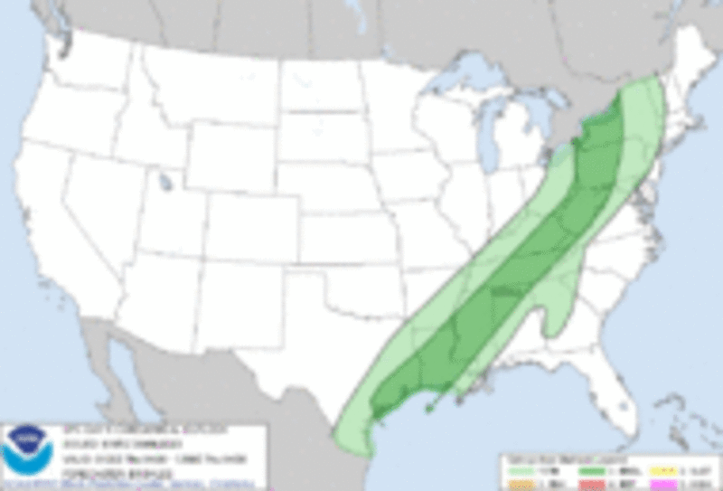
Day 1 Convective Outlook CORR 1
NWS Storm Prediction Center Norman OK
0805 PM CDT Wed Apr 05 2023
Valid 060100Z - 061200Z
...THERE IS A MARGINAL RISK OF SEVERE THUNDERSTORMS ACROSS THE LOWER
GREAT LAKES...CENTRAL APPALACHIANS...TENNESSEE VALLEY...LOWER
MISSISSIPPI VALLEY AND WESTERN GULF COAST STATES...
CORRECTED FOR WORDING
...SUMMARY...
A marginal wind-damage threat will continue this evening for a
couple more hours from the lower Great Lakes southwestward into the
western Gulf Coast states.
...Western Pennsylvania/Western New York...
The latest WSR-88D radar imagery from Pittsburgh shows a line of
thunderstorms, with some embedded stronger cells, located from the
eastern part of Lake Erie southward into western Pennsylvania and
then southwestward into western West Virginia. Along and to the east
of this corridor, the RAP has MLCAPE around 500 J/kg. In spite of
the weak instability, the WSR-88D VWP from College Station has some
speed and directional shear in the lowest 2 kilometer above ground
level. This combined with 50 knot of westerly flow in the mid-levels
is creating strong enough deep-layer shear for an isolated
wind-damage threat. As the line progresses eastward across western
Pennsylvania over the next few hours, a few damaging wind gusts will
be possible. The more discrete cells further to the east across
south-central Pennsylvania could also have a marginal tornado threat
or potential for small hail. The threat could continue for another
hour or two before diminishing.
...Central Appalachians/Tennessee Valley/Lower Mississippi
Valley/Western Gulf Coast...
Mosaic radar imagery across the eastern and southern United States,
shows a relatively broad band of convection located from the central
Appalachians to the western Gulf Coast. The storms are generally
ahead of a front, except in southeast Texas where most of the
convection is post-frontal. Along this band of storms, instability
is generally weak. However, WSR-88D VWPs along this corridor show
strong deep-layer shear, which is associated with the southeastern
edge of a mid-level jet moving through the Upper Midwest. For this
reason, a marginal wind-damage threat will be possible for a few
more hours.
..Broyles.. 04/06/2023
CLICK TO GET WUUS01 PTSDY1 PRODUCT
NOTE: THE NEXT DAY 1 OUTLOOK IS SCHEDULED BY 0600Z
CURRENT UTC TIME: 0201Z
KPIT (Pittsburgh Intl, PA, US)
FEW027 SCT050 OVC100/ 10SM
Temperature: 17.2°C ( 63°F)
Dewpoint: 13.3°C ( 56°F) [RH = 78%]
Pressure (altimeter): 30.08 inches Hg
WINDS: WNW 13MPH/ PK WND 32033/0052
RAB17E46 SLP189 P0000
-----------------------------------
KERI (Erie Intl, PA, US)
BKN085 OVC110/ 10SM -RA
Temperature: 17.2°C ( 63°F)
Dewpoint: 15.0°C ( 59°F) [RH = 87%]
Pressure (altimeter): 29.96 inches Hg
SOUTH 12MPH/ RMK AO2 SLP142 P0005
-----------------------------------
KBUF (Buffalo-Niagara Intl, NY, US)
FEW055 BKN080 OVC100/ 5SM RA BR
Temperature: 16.1°C ( 61°F)
Dewpoint: 15.0°C ( 59°F) [RH = 93%]
Pressure (altimeter): 29.97 inches Hg
WINDS: SSW 10MPH/
------------------------------------
KMDT (Harrisburg Intl, PA, US)
FEW110 OVC250/ 10SM
Temperature: 15.6°C ( 60°F)
Dewpoint: 11.1°C ( 52°F) [RH = 75%]
Pressure (altimeter): 30.03 inches Hg
WINDS: NE 7MPH
---------------------------------
KAOO (Altoona/Blair Cnty, PA, US)
FEW050 BKN080 BKN095/ 10SM VCTS -RA
Temperature: 20.0°C ( 68°F)
Dewpoint: 16.1°C ( 61°F) [RH = 78%]
Pressure (altimeter): 30.04 inches Hg
WINDS: SOUTH 15MPH GUSTING 28MPH
WSHFT 0101 LTG DSNT W RAB01E29B52
PRESRR SLP162 P0002
---------------------------------
KPHL (Philadelphia Intl, PA, US)
BKN170 OVC260/ 10SM
Temperature: 13.9°C ( 57°F)
Dewpoint: 12.2°C ( 54°F) [RH = 89%]
Pressure (altimeter): 30.10 inches Hg
NNE 6MPH
---------------------------
KDAY (Dayton/Cox Intl, OH, US)
SCT008 OVC055/ 10SM
Temperature: 16.1°C ( 61°F)
Dewpoint: 14.4°C ( 58°F) [RH = 90%]
Pressure (altimeter): 30.04 inches
WINDS: SSW 13MPH/ CIG 007 RWY 6L
T01610144 VISNO RWY 6L $
--------------------------------
KFFO (Wright Patterson AFB, OH, US)
FEW023 OVC038/ 10SM -RA
Temperature: 15.7°C ( 60°F)
Dewpoint: 14.7°C ( 58°F) [RH = 94%]
Pressure (altimeter): 30.00 inches Hg
WINDS: SSW 9MPH
------------------------------
KCLE (Cleveland/Hopkins In, OH, US)
FEW095 BKN200/ 10SM
Temperature: 16.7°C ( 62°F)
Dewpoint: 13.9°C ( 57°F) [RH = 84%]
Pressure (altimeter): 29.92 inches Hg
WINDS: SOUTH 14MPH/ RAE47 SLP142
P0006
------------------------
KORD (Chicago/O'Hare Intl, IL, US)
CLEAR 10SM
Temperature: 5.0°C ( 41°F)
Dewpoint: -1.1°C ( 30°F) [RH = 65%]
Pressure (altimeter): 30.04 inches Hg
WINDS: WSW 15MPH GUSTING 22MPH
PK WND 24029/0100 SLP172
---------------------------
KELM (Elmira-Corning Rgnl, NY, US)
FEW060 SCT075 BKN095 / 6SM -RA BR
Temperature: 17.8°C ( 64°F)
Dewpoint: 16.1°C ( 61°F) [RH = 90%]
Pressure (altimeter): 29.99 inches Hg
WINDS: CALM/ P0001
---------------------------------
Current conditions at
Harrisburg, Harrisburg International Airport (KMDT)
Lat: 40.19°NLon: 76.76°WElev: 312ft.
Overcast
60°F / 16°C
Humidity 75%
Wind Speed NE 7 mph
Barometer 30.03 in (1017.0 mb)
Dewpoint 52°F (11°C)
Visibility 10.00 mi
Last update 5 Apr 9:56 pm EDT
Detailed Forecast
Tonight
A chance of showers and thunderstorms before 2am.
Mostly cloudy, with a low around 63. South wind
3 to 8 mph. Chance of precipitation is 40%.
New rainfall amounts between a tenth and
quarter of an inch, except higher amounts
possible in thunderstorms.
Thursday
Showers and thunderstorms, mainly
before 4pm, then showers likely and
possibly a thunderstorm after 4pm.
Some of the storms could produce
gusty winds. High near 75. Light and
variable wind becoming west 9 to 14 mph
in the morning. Winds could gust as
high as 22 mph. Chance of precipitation is
90%. New rainfall amounts between a tenth
and quarter of an inch, except higher amounts
possible in thunderstorms.
Thursday Night
A chance of showers before 11pm.
Mostly cloudy, with a low around 45.
Northwest wind 9 to 11 mph, with gusts
as high as 20 mph. Chance of precipitation
is 30%. New precipitation amounts of less
than a tenth of an inch possible.
Friday
Partly sunny, with a high near 60.
Northwest wind around 11 mph.
Friday Night
Mostly cloudy, with a low around 38.
North wind 6 to 8 mph.
Saturday
Partly sunny, with a high near 55.
Saturday Night
Partly cloudy, with a low around 35.
Sunday
Sunny, with a high near 60.
Sunday Night
Mostly clear, with a low around 36.
Monday
Sunny, with a high near 64.
Monday Night
Partly cloudy, with a low around 41.
Tuesday
Mostly sunny, with a high near 70.
Tuesday Night
Mostly clear, with a low around 47.
Wednesday
Sunny, with a high near 77.
Hazardous Weather Outlook
Hazardous Weather Outlook
National Weather Service State College PA
433 AM EDT Wed Apr 5 2023
PAZ012-017>019-024>028-033>037-041-045-046-049>052-056-057-063-064-
060845-
Northern Clinton-Clearfield-Northern Centre-Southern Centre-Cambria-
Blair-Huntingdon-Mifflin-Juniata-Somerset-Bedford-Fulton-Franklin-
Tioga-Northern Lycoming-Southern Clinton-Southern Lycoming-Union-
Snyder-Montour-Northumberland-Perry-Dauphin-Cumberland-Adams-
433 AM EDT Wed Apr 5 2023
This Hazardous Weather Outlook is for central Pennsylvania.
.DAY ONE...Today and tonight.
Scattered thunderstorms are possible this afternoon and evening, a
few of which could produce strong wind gusts.
.DAYS TWO THROUGH SEVEN...Thursday through Tuesday.
The probability for widespread hazardous weather is low.
.SPOTTER INFORMATION STATEMENT...
Spotter activation is not expected at this time.
-------------------------------
Strong Storms from the Great Lakes Region
into Mid-Mississippi Valley
Forecaster: Kerr
Issued: 05/0815Z
Valid: Sat 04/08 1200Z - Wed 04/12 1200Z
Note: A severe weather area depicted in the
Day 4-8 period indicates a 15%, 30% or higher
probability for severe thunderstorms
(e.g. a 15%, 30% chance that a severe
thunderstorm will occur within 25 miles of any point).
SPC Day 1 Outlook
Posted from spc.noaa.gov
Posted >1 y ago
Read This Next
