
Gulfport, MS
Gulfport, MS
")
9
9
0
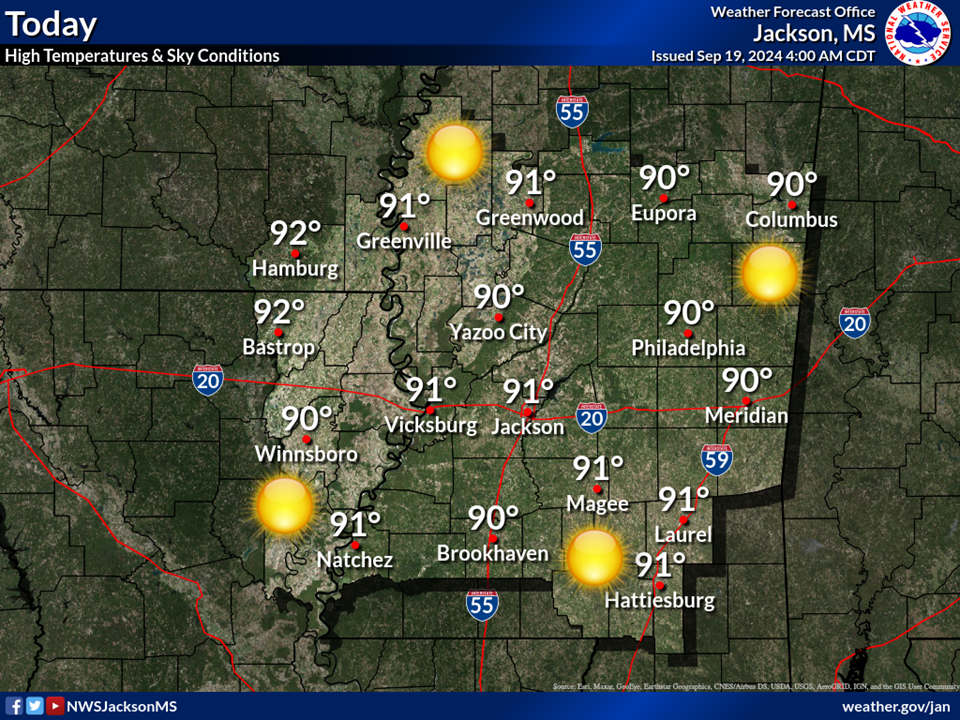
KBIX Biloxi, MS. CLR 7 88 72 60 SSW12 30.01
KCBM Columbus AFB, MS. CLR 7 91 67 46 W6 29.99
KGLH Greenvile, MS. SCT 7 87 73 63 SW7 29.96 LTG DSNT N AN NW/
KGPT Gulfport, MS. SCT 7 88 71 57 S9 30.01
KGTR Columbus, MS. CLR 7 90 69 50 SSW7 30.00
KGWO Greenwood, MS. SCT 7 89 71 56 SSE13 29.97
KHBG Hattiesburg, MS. CLR 7 91 65 42 CALM 30.00
KHEZ Natchez, MS. CLR 7 90 72 56 S5 30.00
KHKS Jackson, MS. SCT 7 90 70 52 SSE8 29.99 LTG DSNT SW/
KJAN Jackson, MS. BKN 7 90 68 49 SSE8 29.98 LTG DSNT N/
KMCB McComb, MS. BKN 7 82 71 69 SW5 30.02 RAB30E41 P0001/
KMEI Meridian, MS. BKN 7 93 65 40 WSW6 29.99
KNMM Meridian NAS, MS. BKN 7 88 67 50 S5 29.99
KOLV Olive Branch Airport,MS BKN 7 82 72 70 S6 29.9
KPIB Laurel-Hattiesburg BKN 7 82 72 70 S6 29.96
KPQL Pascagoula,MS. CLR 7 88 70 55 VRB07 30.01
KTUP Tupelo, MS. CLR 7 89 67 48 SSW9 29.98
KTVR Vicksburg, MS. SCT 7 84 73 70 VRB03 29.98 LTG DSNT N AND NW/
KUTA Tunica Muni Airport,MS SCT 7 VCTS 70 70 100 S8 30.00
KMSY New Orleans, LA. SCT 82 70 67 S8 30.03 CB DSNT S/
RAB = RAIN BEGAN E = END LGT = LIGHTNING CIG VARY = CLOUD BASES
CLR = CLEAR DSNT = DISTANT SLP178 SEA LEVEL PRESSURE
SCT = SCATTERED PARTLY CLOUDY WSHFT = WIND SHIFT PRESFR = PRESSURE FALLING RAPIDLY
BKN = BROKEN MOSTLY CLOUDY ALQDS = TOTALLY SURROUNDING PRESRR = PRESSURE RISING RAPIDLY
OVC = OVERCAST TSB = THUNDERSTORM BEGAN P0000 = ZERO RAIN
Monday 7/29/2019 SA2315GMT/ZULU/Z
METEOROLOGIST LARRY OLSON
BROADCAST METEOROLOGIST MIKE SCOTT
Hazardous Weather Outlook
National Weather Service Jackson MS
259 PM CDT Mon Jul 29 2019
ARZ074-075-LAZ007-008-MSZ018 [login to see] 00-
Ashley-Chicot-Morehouse-West Carroll-Bolivar-Sunflower-Washington-
259 PM CDT Mon Jul 29 2019
This hazardous weather outlook is for portions of southeast
Arkansas, northeast Louisiana, and northwest Mississippi.
.DAY ONE...Tonight and Tuesday
SEVERE THUNDERSTORMS
THREAT...Marginal
TIMING...The rest of this afternoon through this evening
Isolated severe thunderstorms will be possible this afternoon and
evening as a front drops into the region. Damaging winds will be
the main concern.
(https://www.weather.gov/images/jan/graphicast/1.png)
.DAYS TWO THROUGH SEVEN...Tuesday night through Sunday
The probability for widespread hazardous weather is low.
.SPOTTER CALL TO ACTION STATEMENT...
The activation of storm spotters, HAM radio operators, and
emergency management personnel in support of severe weather
operations may be needed for portions of the region remainder
of the afternoon through tonight.
https://radar.weather.gov/radar.php?rid=DGX&product=N0R&overlay=11101111&loop=yes
)
National Weather Service
Posted from weather.gov
Posted >1 y ago
Responses: 4
Read This Next
