
8
8
0
any questions, email or in topics here.
===============================================
BULLETIN
Hurricane Delta Intermediate Advisory Number 9A...Corrected
NWS National Hurricane Center Miami FL AL262020
800 PM EDT Tue Oct 06 2020
Corrected distance from Cozumel
...EXTREMELY DANGEROUS CATEGORY FOUR HURRICANE DELTA HEADING
TOWARD THE NORTHEASTERN COAST OF THE YUCATAN PENINSULA...
...EXPECTED TO BRING A LIFE-THREATENING STORM SURGE AND EXTREME
WINDS...
SUMMARY OF 800 PM EDT...0000 UTC...INFORMATION
----------------------------------------------
LOCATION...19.2N 84.5W
ABOUT 180 MI...290 KM ESE OF COZUMEL MEXICO
MAXIMUM SUSTAINED WINDS...145 MPH...230 KM/H
PRESENT MOVEMENT...WNW OR 300 DEGREES AT 17 MPH...28 KM/H
MINIMUM CENTRAL PRESSURE...956 MB...28.23 INCHES
WATCHES AND WARNINGS
--------------------
CHANGES WITH THIS ADVISORY:
None.
SUMMARY OF WATCHES AND WARNINGS IN EFFECT:
A Hurricane Warning is in effect for...
* Tulum to Dzilam Mexico
* Cozumel
A Tropical Storm Warning is in effect for...
* Cuba province of Pinar del Rio
* Isle of Youth
* Punta Herrero to Tulum Mexico
* Dzilam to Progreso Mexico
A Hurricane Warning means that hurricane conditions are expected
somewhere within the warning area. Preparations to protect life
and property should be rushed to completion.
A Tropical Storm Warning means that tropical storm conditions are
expected somewhere within the warning area within 36 hours.
Interests along the northern Gulf of Mexico coast should monitor
the progress of Delta. Hurricane and Storm Surge Watches will
likely be issued for a portion of this area on Wednesday.
For storm information specific to your area, please monitor
products issued by your national meteorological service.
DISCUSSION AND OUTLOOK
----------------------
At 800 PM EDT (0000 UTC), the center of Hurricane Delta was located
by a NOAA Hurricane Hunter aircraft near latitude 19.2 North,
longitude 84.5 West. Delta is moving toward the west-northwest near
17 mph (28 km/h). A west-northwestward to northwestward motion is
expected over the next couple of days. A slower northwestward to
north-northwestward motion is forecast to begin on Thursday, and a
northward motion is expected Thursday night and Friday. On the
forecast track, the center of Delta will move over the northeastern
portion of the Yucatan peninsula late tonight or early Wednesday.
Delta is forecast to move over the southern Gulf of Mexico Wednesday
afternoon, be over the southern or central Gulf of Mexico through
Thursday, and approach the northern Gulf coast on Friday.
Maximum sustained winds are near 145 mph (230 km/h) with higher
gusts. Delta is a category 4 hurricane on the Saffir-Simpson
Hurricane Wind Scale. Some strengthening is possible before the
center reaches the coast of the Yucatan peninsula early Wednesday.
Although some weakening is likely when Delta moves over the Yucatan
peninsula, re-strengthening is forecast when the hurricane moves
over the southern Gulf of Mexico Wednesday night and Thursday.
Hurricane-force winds extend outward up to 30 miles (45 km) from
the center and tropical-storm-force winds extend outward up to 105
miles (165 km).
The estimated minimum central pressure is 956 mb (28.23 inches).
HAZARDS AFFECTING LAND
----------------------
Key messages for Delta can be found in the Tropical Cyclone
Discussion under AWIPS header MIATCDAT1, WMO header WTNT41
KNHC, and on the web at http://www.hurricanes.gov/text/MIATCDAT1.shtml.
STORM SURGE: A life-threatening storm surge will raise water levels
in areas of onshore winds by as much as 9 to 13 ft above normal tide
levels along the northern coast of the Yucatan Peninsula from Cabo
Catoche to Progresso, and 6 to 9 ft above normal tide levels along
the eastern coast of the Yucatan Peninsula from Tulum to Cabo
Catoche. Near the coast, the surge will be accompanied by large
and destructive waves.
WIND: In the Yucatan Peninsula, potentially catastrophic
hurricane conditions are expected in portions of the warning area
late tonight and early Wednesday, with tropical storm conditions
beginning later this evening. Tropical storm conditions are
expected in the tropical storm warning area tonight and Wednesday.
In Cuba, tropical storm conditions are expected tonight in the
warning area.
RAINFALL: Delta is expected to produce 4 to 6 inches of rain, with
isolated maximum totals of 10 inches, across portions of the
northern Yucatan Peninsula through midweek. This rainfall may result
in areas of significant flash flooding.
Over the next few days, Delta is expected to produce 2 to 4 inches
of rain, with isolated higher amounts, across portions of the Cayman
Islands and western Cuba. This rainfall may result in areas of
flash flooding and mudslides.
Later this week, Delta is expected to produce 4 to 8 inches of rain,
with isolated maximum totals of 12 inches, over portions of the
central Gulf Coast. These rainfall amounts may lead to flash,
urban and minor river flooding. Heavy rainfall will eventually
spread into the Tennessee Valley, and interior southeastern United
States as well.
SURF: Swells generated by Delta will affected land areas around
the northwestern Caribbean Sea for the next day or so. These swells
are likely to cause life-threatening surf and rip current
conditions. Please consult products from your local weather office.
================================================
HURRICANE DELTA FORECAST/ADVISORY NUMBER 9
NWS NATIONAL HURRICANE CENTER MIAMI FL AL [login to see] UTC TUE OCT 06 2020
CHANGES IN WATCHES AND WARNINGS WITH THIS ADVISORY...
THE GOVERNMENT OF CUBA HAS DISCONTINUED THE TROPICAL STORM WATCH
FOR THE PROVINCE OF LA HABANA.
SUMMARY OF WATCHES AND WARNINGS IN EFFECT...
A HURRICANE WARNING IS IN EFFECT FOR...
* TULUM TO DZILAM MEXICO
* COZUMEL
A TROPICAL STORM WARNING IS IN EFFECT FOR...
* CUBA PROVINCE OF PINAR DEL RIO
* ISLE OF YOUTH
* PUNTA HERRERO TO TULUM MEXICO
* DZILAM TO PROGRESSO MEXICO
A HURRICANE WARNING MEANS THAT HURRICANE CONDITIONS ARE EXPECTED
SOMEWHERE WITHIN THE WARNING AREA. PREPARATIONS TO PROTECT LIFE
AND PROPERTY SHOULD BE RUSHED TO COMPLETION.
A TROPICAL STORM WARNING MEANS THAT TROPICAL STORM CONDITIONS ARE
EXPECTED SOMEWHERE WITHIN THE WARNING AREA WITHIN 36 HOURS.
INTERESTS ALONG THE NORTHERN GULF OF MEXICO COAST SHOULD MONITOR
THE PROGRESS OF DELTA. HURRICANE AND STORM SURGE WATCHES WILL
LIKELY BE ISSUED FOR A PORTION OF THIS AREA ON WEDNESDAY.
HURRICANE CENTER LOCATED NEAR 18.9N 84.1W AT 06/2100Z
POSITION ACCURATE WITHIN 15 NM
PRESENT MOVEMENT TOWARD THE WEST-NORTHWEST OR 300 DEGREES AT 15 KT
ESTIMATED MINIMUM CENTRAL PRESSURE 956 MB
EYE DIAMETER 5 NM
MAX SUSTAINED WINDS 125 KT WITH GUSTS TO 150 KT.
64 KT....... 25NE 20SE 15SW 20NW.
50 KT....... 40NE 30SE 30SW 30NW.
34 KT....... 90NE 80SE 60SW 80NW.
12 FT SEAS..150NE 60SE 30SW 90NW.
WINDS AND SEAS VARY GREATLY IN EACH QUADRANT. RADII IN NAUTICAL
MILES ARE THE LARGEST RADII EXPECTED ANYWHERE IN THAT QUADRANT.
REPEAT...CENTER LOCATED NEAR 18.9N 84.1W AT 06/2100Z
AT 06/1800Z CENTER WAS LOCATED NEAR 18.5N 83.5W
FORECAST VALID 07/0600Z 20.2N 86.1W
MAX WIND 135 KT...GUSTS 165 KT.
64 KT... 25NE 20SE 15SW 20NW.
50 KT... 40NE 30SE 30SW 30NW.
34 KT...100NE 80SE 60SW 80NW.
FORECAST VALID 07/1800Z 21.8N 88.8W
MAX WIND 105 KT...GUSTS 130 KT.
64 KT... 25NE 20SE 15SW 20NW.
50 KT... 50NE 40SE 20SW 40NW.
34 KT...110NE 80SE 60SW 90NW.
FORECAST VALID 08/0600Z 23.0N 91.1W
MAX WIND 110 KT...GUSTS 135 KT.
64 KT... 30NE 25SE 20SW 25NW.
50 KT... 60NE 40SE 30SW 40NW.
34 KT...120NE 100SE 70SW 100NW.
FORECAST VALID 08/1800Z 24.4N 92.6W
MAX WIND 115 KT...GUSTS 140 KT.
64 KT... 30NE 25SE 20SW 30NW.
50 KT... 60NE 50SE 40SW 50NW.
34 KT...140NE 120SE 80SW 110NW.
FORECAST VALID 09/0600Z 25.9N 93.2W
MAX WIND 115 KT...GUSTS 140 KT.
50 KT... 60NE 50SE 40SW 50NW.
34 KT...140NE 120SE 80SW 110NW.
FORECAST VALID 09/1800Z 28.0N 92.9W
MAX WIND 110 KT...GUSTS 135 KT.
50 KT... 60NE 60SE 40SW 50NW.
34 KT...140NE 130SE 90SW 110NW.
EXTENDED OUTLOOK. NOTE...ERRORS FOR TRACK HAVE AVERAGED NEAR 150 NM
ON DAY 4 AND 175 NM ON DAY 5...AND FOR INTENSITY NEAR 15 KT EACH DAY
OUTLOOK VALID 10/1800Z 32.4N 90.9W...INLAND
MAX WIND 55 KT...GUSTS 65 KT.
OUTLOOK VALID 11/1800Z 35.5N 87.3W...POST-TROP/REMNT LOW
MAX WIND 20 KT...GUSTS 30 KT.
REQUEST FOR 3 HOURLY SHIP REPORTS WITHIN 300 MILES OF 18.9N 84.1W
INTERMEDIATE PUBLIC ADVISORY...WTNT31 KNHC/MIATCPAT1...AT 07/0000Z
NEXT ADVISORY AT 07/0300Z
================================================
Hurricane Delta Discussion Number 9
NWS National Hurricane Center Miami FL AL262020
500 PM EDT Tue Oct 06 2020
Shortly after the release of the 1500 UTC advisory package, the
NOAA Hurricane Hunter aircraft measured a peak flight-level wind
of 132 kt, and during its final passage through the northeast
eyewall around 1700 UTC it reported a peak SFMR wind of 121 kt.
The aircraft continued to report an extremely small 4-to-5-nmi-wide
eye. The central pressure did level off somewhat on the final
couple of penetrations, with the latest reported central pressure
at 956 mb. The initial wind speed was raised to 120 kt on the
earlier intermediate advisory, and has been set at 125 kt for this
advisory. The next reconnaissance aircraft mission into the
hurricane is scheduled for this evening.
There has been no evidence of an outer eyewall from the aircraft
reports or earlier radar imagery from Grand Cayman. As a
result, some additional strengthening is likely to occur before
Delta reaches the northeastern coast of the Yucatan peninsula late
tonight or early Wednesday. The NHC intensity forecast is once
again a little above the various intensity aids until landfall in
Mexico. When the small inner core of Delta moves over land,
weakening is expected, but warm waters and low vertical wind shear
over the southern Gulf of Mexico should support re-strengthening,
and a second peak in intensity is likely when Delta is over the
central Gulf of Mexico in 48-60 hours. After that time, increasing
southwesterly shear and the cooler shelf waters over the
northern Gulf are expected to cause some reduction in wind speed.
The global models, however, depict a significant increase in the
size of Delta's wind field while it is over the Gulf of Mexico,
which increases the spatial extent of the storm surge and wind
threats for the northern Gulf coast. So regardless of Delta's
final landfall intensity, the projected large size of the hurricane
is likely to result in a significant storm surge and wind event for
portions of the northern Gulf coast later this week.
Delta has been moving steadily west-northwestward today at 300/15
kt. The track forecast reasoning remains unchanged from the previous
advisory. A mid-level ridge over Florida and the northeastern Gulf
of Mexico is expected to continue steering Delta west-northwestward
during the next 36-48 hours. After that time, a developing trough
over the south-central United States should cause Delta to turn
northward, and by Friday the hurricane is forecast to begin
accelerating northward or north-northeastward ahead of the trough.
This motion will bring Delta onshore along the northern Gulf coast
between 72 and 96 hours. The dynamical models continue to be
tightly clustered through 48-72 hours with some increase in spread
thereafter. The overall trend in the guidance has been slightly
westward, and the new forecast has been adjusted accordingly and
lies near the middle of the envelope. Supplemental upper-air balloon
launches at 0600 and 1800 UTC have begun at upper-air sites across
portions of the southeastern United States. In addition, a NOAA
G-IV synoptic surveillance mission is in progress and should provide
additional data for the 0000 UTC cycle of the dynamical models.
Key Messages:
1. Life-threatening storm surge and potentially catastrophic wind
damage are expected within portions of the northern Yucatan
Peninsula of Mexico beginning tonight. All preparations to protect
life and property should be rushed to completion.
2. Heavy rainfall will affect portions of the Cayman Islands,
western Cuba and the northern Yucatan Peninsula through midweek.
This rainfall could lead to significant flash flooding and
mudslides. The potential for heavy rain, flash and possible minor
river flooding will increase across portions of the central Gulf
Coast, Tennessee Valley, and southeastern United States as Delta
moves inland later this week.
3. There is an increasing likelihood of life-threatening storm surge
and dangerous hurricane-force winds, especially along the coasts of
Louisiana and Mississippi, beginning on Friday. Residents in these
areas should ensure they have their hurricane plan in place and
follow advice given by local officials. Storm surge and hurricane
watches will likely be issued for portions of the northern Gulf
Coast on Wednesday.
FORECAST POSITIONS AND MAX WINDS
INIT 06/2100Z 18.9N 84.1W 125 KT 145 MPH
12H 07/0600Z 20.2N 86.1W 135 KT 155 MPH
24H 07/1800Z 21.8N 88.8W 105 KT 120 MPH
36H 08/0600Z 23.0N 91.1W 110 KT 125 MPH
48H 08/1800Z 24.4N 92.6W 115 KT 130 MPH
60H 09/0600Z 25.9N 93.2W 115 KT 130 MPH
72H 09/1800Z 28.0N 92.9W 110 KT 125 MPH
96H 10/1800Z 32.4N 90.9W 55 KT 65 MPH...INLAND
120H 11/1800Z 35.5N 87.3W 20 KT 25 MPH...POST-TROP/REMNT LOW
=================================================
HURRICANE DELTA WIND SPEED PROBABILITIES NUMBER 9
NWS NATIONAL HURRICANE CENTER MIAMI FL AL262020
2100 UTC TUE OCT 06 2020
AT 2100Z THE CENTER OF HURRICANE DELTA WAS LOCATED NEAR LATITUDE
18.9 NORTH...LONGITUDE 84.1 WEST WITH MAXIMUM SUSTAINED WINDS NEAR
125 KTS...145 MPH...230 KM/H.
Z INDICATES COORDINATED UNIVERSAL TIME (GREENWICH)
ATLANTIC STANDARD TIME (AST)...SUBTRACT 4 HOURS FROM Z TIME
EASTERN DAYLIGHT TIME (EDT)...SUBTRACT 4 HOURS FROM Z TIME
CENTRAL DAYLIGHT TIME (CDT)...SUBTRACT 5 HOURS FROM Z TIME
WIND SPEED PROBABILITY TABLE FOR SPECIFIC LOCATIONS
CHANCES OF SUSTAINED (1-MINUTE AVERAGE) WIND SPEEDS OF AT LEAST
...34 KT (39 MPH... 63 KM/H)...
...50 KT (58 MPH... 93 KM/H)...
...64 KT (74 MPH...119 KM/H)...
FOR LOCATIONS AND TIME PERIODS DURING THE NEXT 5 DAYS
PROBABILITIES FOR LOCATIONS ARE GIVEN AS OP(CP) WHERE
OP IS THE PROBABILITY OF THE EVENT BEGINNING DURING
AN INDIVIDUAL TIME PERIOD (ONSET PROBABILITY)
(CP) IS THE PROBABILITY OF THE EVENT OCCURRING BETWEEN
18Z TUE AND THE FORECAST HOUR (CUMULATIVE PROBABILITY)
PROBABILITIES ARE GIVEN IN PERCENT
X INDICATES PROBABILITIES LESS THAN 1 PERCENT
PROBABILITIES FOR 34 KT AND 50 KT ARE SHOWN AT A GIVEN LOCATION WHEN
THE 5-DAY CUMULATIVE PROBABILITY IS AT LEAST 3 PERCENT.
PROBABILITIES FOR 34...50...64 KT SHOWN WHEN THE 5-DAY
64-KT CUMULATIVE PROBABILITY IS AT LEAST 1 PERCENT.
- - - - WIND SPEED PROBABILITIES FOR SELECTED LOCATIONS - - - -
FROM FROM FROM FROM FROM FROM FROM
TIME 18Z TUE 06Z WED 18Z WED 06Z THU 18Z THU 18Z FRI 18Z SAT
PERIODS TO TO TO TO TO TO TO
06Z WED 18Z WED 06Z THU 18Z THU 18Z FRI 18Z SAT 18Z SUN
FORECAST HOUR (12) (24) (36) (48) (72) (96) (120)
- - - - - - - - - - - - - - - - - - - - - - - - - - - - - - - - - -
LOCATION KT
ATLANTA GA 34 X X( X) X( X) X( X) X( X) 3( 3) 2( 5)
TALLAHASSEE FL 34 X X( X) X( X) X( X) X( X) 3( 3) 1( 4)
ST MARKS FL 34 X X( X) X( X) X( X) X( X) 2( 2) 1( 3)
APALACHICOLA 34 X X( X) X( X) X( X) X( X) 5( 5) 1( 6)
GFMX 290N 850W 34 X X( X) X( X) X( X) 1( 1) 3( 4) 1( 5)
PANAMA CITY FL 34 X X( X) X( X) X( X) 1( 1) 7( 8) 1( 9)
DESTIN EXEC AP 34 X X( X) X( X) X( X) 1( 1) 10(11) 2(13)
DESTIN EXEC AP 50 X X( X) X( X) X( X) X( X) 2( 2) 1( 3)
DESTIN EXEC AP 64 X X( X) X( X) X( X) X( X) 1( 1) X( 1)
COLUMBUS GA 34 X X( X) X( X) X( X) X( X) 5( 5) 2( 7)
BIRMINGHAM AL 34 X X( X) X( X) X( X) X( X) 10(10) 6(16)
MONTGOMERY AL 34 X X( X) X( X) X( X) X( X) 10(10) 4(14)
WHITING FLD FL 34 X X( X) X( X) X( X) 2( 2) 13(15) 4(19)
WHITING FLD FL 50 X X( X) X( X) X( X) X( X) 2( 2) 1( 3)
WHITING FLD FL 64 X X( X) X( X) X( X) X( X) 1( 1) X( 1)
PENSACOLA FL 34 X X( X) X( X) X( X) 2( 2) 15(17) 3(20)
PENSACOLA FL 50 X X( X) X( X) X( X) X( X) 3( 3) 1( 4)
GFMX 290N 870W 34 X X( X) X( X) X( X) 5( 5) 10(15) 1(16)
GFMX 290N 870W 50 X X( X) X( X) X( X) X( X) 3( 3) X( 3)
GFMX 290N 870W 64 X X( X) X( X) X( X) X( X) 1( 1) X( 1)
MOBILE AL 34 X X( X) X( X) X( X) 5( 5) 24(29) 4(33)
MOBILE AL 50 X X( X) X( X) X( X) X( X) 7( 7) 1( 8)
MOBILE AL 64 X X( X) X( X) X( X) X( X) 3( 3) 1( 4)
GULFPORT MS 34 X X( X) X( X) X( X) 10(10) 28(38) 4(42)
GULFPORT MS 50 X X( X) X( X) X( X) 2( 2) 10(12) 2(14)
GULFPORT MS 64 X X( X) X( X) X( X) 1( 1) 4( 5) 1( 6)
STENNIS MS 34 X X( X) X( X) X( X) 12(12) 34(46) 3(49)
STENNIS MS 50 X X( X) X( X) X( X) 3( 3) 14(17) 2(19)
STENNIS MS 64 X X( X) X( X) X( X) 1( 1) 6( 7) 1( 8)
BURAS LA 34 X X( X) X( X) 1( 1) 16(17) 28(45) 2(47)
BURAS LA 50 X X( X) X( X) X( X) 4( 4) 12(16) 1(17)
BURAS LA 64 X X( X) X( X) X( X) 1( 1) 6( 7) X( 7)
GFMX 280N 890W 34 X X( X) 1( 1) 4( 5) 22(27) 10(37) 1(38)
GFMX 280N 890W 50 X X( X) X( X) X( X) 3( 3) 5( 8) X( 8)
GFMX 280N 890W 64 X X( X) X( X) X( X) 1( 1) 2( 3) X( 3)
JACKSON MS 34 X X( X) X( X) X( X) 5( 5) 37(42) 6(48)
JACKSON MS 50 X X( X) X( X) X( X) X( X) 15(15) 3(18)
JACKSON MS 64 X X( X) X( X) X( X) X( X) 4( 4) 1( 5)
NEW ORLEANS LA 34 X X( X) X( X) 1( 1) 19(20) 38(58) 3(61)
NEW ORLEANS LA 50 X X( X) X( X) X( X) 5( 5) 20(25) 1(26)
NEW ORLEANS LA 64 X X( X) X( X) X( X) 2( 2) 11(13) 1(14)
GFMX 280N 910W 34 X X( X) 2( 2) 9(11) 48(59) 12(71) 1(72)
GFMX 280N 910W 50 X X( X) X( X) 1( 1) 24(25) 10(35) 1(36)
GFMX 280N 910W 64 X X( X) X( X) X( X) 12(12) 7(19) X(19)
BATON ROUGE LA 34 X X( X) X( X) 1( 1) 23(24) 42(66) 4(70)
BATON ROUGE LA 50 X X( X) X( X) X( X) 7( 7) 27(34) 3(37)
BATON ROUGE LA 64 X X( X) X( X) X( X) 3( 3) 15(18) 1(19)
MORGAN CITY LA 34 X X( X) X( X) 1( 1) 32(33) 37(70) 2(72)
MORGAN CITY LA 50 X X( X) X( X) X( X) 11(11) 26(37) 2(39)
MORGAN CITY LA 64 X X( X) X( X) X( X) 4( 4) 14(18) 1(19)
ALEXANDRIA LA 34 X X( X) X( X) X( X) 16(16) 41(57) 3(60)
ALEXANDRIA LA 50 X X( X) X( X) X( X) 4( 4) 23(27) 2(29)
ALEXANDRIA LA 64 X X( X) X( X) X( X) 1( 1) 11(12) 1(13)
LAFAYETTE LA 34 X X( X) X( X) 1( 1) 30(31) 41(72) 3(75)
LAFAYETTE LA 50 X X( X) X( X) X( X) 12(12) 30(42) 3(45)
LAFAYETTE LA 64 X X( X) X( X) X( X) 5( 5) 19(24) 1(25)
NEW IBERIA LA 34 X X( X) X( X) 1( 1) 33(34) 39(73) 3(76)
NEW IBERIA LA 50 X X( X) X( X) X( X) 12(12) 31(43) 3(46)
NEW IBERIA LA 64 X X( X) X( X) X( X) 6( 6) 17(23) 2(25)
GFMX 280N 930W 34 X X( X) 1( 1) 14(15) 65(80) 10(90) 1(91)
GFMX 280N 930W 50 X X( X) X( X) 1( 1) 51(52) 15(67) 1(68)
GFMX 280N 930W 64 X X( X) X( X) X( X) 32(32) 12(44) 1(45)
SHREVEPORT LA 34 X X( X) X( X) X( X) 5( 5) 22(27) 3(30)
SHREVEPORT LA 50 X X( X) X( X) X( X) 1( 1) 8( 9) X( 9)
FORT POLK LA 34 X X( X) X( X) X( X) 18(18) 35(53) 3(56)
FORT POLK LA 50 X X( X) X( X) X( X) 4( 4) 22(26) 1(27)
FORT POLK LA 64 X X( X) X( X) X( X) 2( 2) 11(13) X(13)
LAKE CHARLES 34 X X( X) X( X) 1( 1) 28(29) 37(66) 2(68)
LAKE CHARLES 50 X X( X) X( X) X( X) 12(12) 25(37) 1(38)
LAKE CHARLES 64 X X( X) X( X) X( X) 5( 5) 13(18) 1(19)
CAMERON LA 34 X X( X) X( X) 2( 2) 50(52) 25(77) 1(78)
CAMERON LA 50 X X( X) X( X) X( X) 20(20) 25(45) 2(47)
CAMERON LA 64 X X( X) X( X) X( X) 11(11) 14(25) X(25)
JASPER TX 34 X X( X) X( X) X( X) 17(17) 29(46) 1(47)
JASPER TX 50 X X( X) X( X) X( X) 5( 5) 14(19) 1(20)
JASPER TX 64 X X( X) X( X) X( X) 2( 2) 8(10) 1(11)
KOUNTZE TX 34 X X( X) X( X) 1( 1) 19(20) 28(48) 1(49)
KOUNTZE TX 50 X X( X) X( X) X( X) 7( 7) 14(21) 1(22)
KOUNTZE TX 64 X X( X) X( X) X( X) 4( 4) 8(12) X(12)
PORT ARTHUR TX 34 X X( X) X( X) 1( 1) 25(26) 29(55) 2(57)
PORT ARTHUR TX 50 X X( X) X( X) X( X) 11(11) 18(29) X(29)
PORT ARTHUR TX 64 X X( X) X( X) X( X) 5( 5) 11(16) X(16)
GALVESTON TX 34 X X( X) X( X) 3( 3) 38(41) 16(57) 1(58)
GALVESTON TX 50 X X( X) X( X) X( X) 15(15) 11(26) X(26)
GALVESTON TX 64 X X( X) X( X) X( X) 8( 8) 6(14) 1(15)
HOUSTON TX 34 X X( X) X( X) 1( 1) 16(17) 15(32) 1(33)
HOUSTON TX 50 X X( X) X( X) X( X) 5( 5) 6(11) X(11)
HOUSTON TX 64 X X( X) X( X) X( X) 2( 2) 4( 6) X( 6)
AUSTIN TX 34 X X( X) X( X) X( X) 2( 2) 4( 6) X( 6)
SAN ANTONIO TX 34 X X( X) X( X) X( X) 2( 2) 2( 4) X( 4)
FREEPORT TX 34 X X( X) X( X) 1( 1) 21(22) 12(34) X(34)
FREEPORT TX 50 X X( X) X( X) X( X) 6( 6) 5(11) 1(12)
FREEPORT TX 64 X X( X) X( X) X( X) 2( 2) 3( 5) X( 5)
GFMX 280N 950W 34 X X( X) X( X) 9( 9) 44(53) 9(62) 1(63)
GFMX 280N 950W 50 X X( X) X( X) 1( 1) 25(26) 6(32) 1(33)
GFMX 280N 950W 64 X X( X) X( X) X( X) 14(14) 4(18) X(18)
HIGH ISLAND TX 34 X X( X) X( X) 1( 1) 27(28) 23(51) 1(52)
HIGH ISLAND TX 50 X X( X) X( X) X( X) 11(11) 13(24) X(24)
HIGH ISLAND TX 64 X X( X) X( X) X( X) 5( 5) 8(13) X(13)
MATAGORDA TX 34 X X( X) X( X) 2( 2) 26(28) 9(37) 1(38)
MATAGORDA TX 50 X X( X) X( X) X( X) 7( 7) 4(11) X(11)
MATAGORDA TX 64 X X( X) X( X) X( X) 3( 3) 1( 4) X( 4)
PORT O CONNOR 34 X X( X) X( X) 2( 2) 22(24) 6(30) 1(31)
PORT O CONNOR 50 X X( X) X( X) X( X) 4( 4) 2( 6) X( 6)
PORT O CONNOR 64 X X( X) X( X) X( X) 1( 1) 2( 3) X( 3)
ROCKPORT TX 34 X X( X) X( X) 1( 1) 7( 8) 4(12) X(12)
CORPUS CHRISTI 34 X X( X) X( X) 1( 1) 5( 6) 3( 9) X( 9)
GFMX 270N 960W 34 X X( X) X( X) 9( 9) 29(38) 4(42) 1(43)
GFMX 270N 960W 50 X X( X) X( X) 1( 1) 10(11) 2(13) X(13)
GFMX 270N 960W 64 X X( X) X( X) X( X) 4( 4) 1( 5) X( 5)
MCALLEN TX 34 X X( X) X( X) 1( 1) 3( 4) X( 4) X( 4)
HARLINGEN TX 34 X X( X) X( X) 1( 1) 5( 6) 1( 7) X( 7)
BROWNSVILLE TX 34 X X( X) X( X) 2( 2) 5( 7) 1( 8) 1( 9)
GFMX 250N 960W 34 X X( X) 2( 2) 12(14) 17(31) 2(33) X(33)
GFMX 250N 960W 50 X X( X) X( X) 1( 1) 6( 7) 1( 8) X( 8)
GFMX 250N 960W 64 X X( X) X( X) X( X) 3( 3) X( 3) X( 3)
LA PESCA MX 34 X X( X) X( X) 1( 1) 2( 3) X( 3) X( 3)
FRONTERA MX 34 X 1( 1) 1( 2) X( 2) 1( 3) X( 3) X( 3)
MERIDA MX 34 1 36(37) 12(49) 2(51) X(51) X(51) X(51)
MERIDA MX 50 X 7( 7) 6(13) 1(14) X(14) X(14) X(14)
MERIDA MX 64 X 2( 2) 3( 5) X( 5) X( 5) X( 5) X( 5)
COZUMEL MX 34 94 6(99) X(99) X(99) X(99) X(99) X(99)
COZUMEL MX 50 30 64(94) X(94) X(94) X(94) X(94) X(94)
COZUMEL MX 64 8 70(78) X(78) X(78) X(78) X(78) X(78)
BELIZE CITY 34 1 2( 3) X( 3) X( 3) X( 3) X( 3) X( 3)
CP SAN ANTONIO 34 17 6(23) 1(24) X(24) X(24) X(24) X(24)
PENSACOLA NAS 34 X X( X) X( X) X( X) 4( 4) 17(21) 2(23)
PENSACOLA NAS 50 X X( X) X( X) X( X) X( X) 4( 4) 1( 5)
PENSACOLA NAS 64 X X( X) X( X) X( X) X( X) 1( 1) 1( 2)
KEESLER AB 34 X X( X) X( X) X( X) 13(13) 26(39) 3(42)
KEESLER AB 50 X X( X) X( X) X( X) 2( 2) 9(11) 2(13)
KEESLER AB 64 X X( X) X( X) X( X) 1( 1) 4( 5) 1( 6)
====================================================
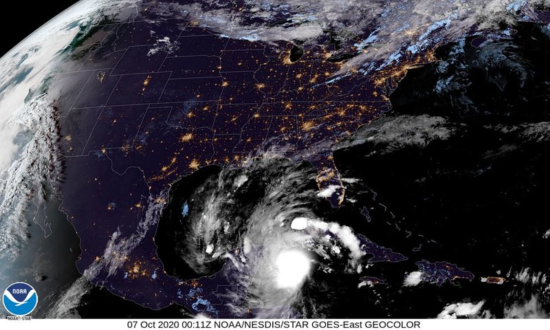
GOES-East - Sector view: Tropical Atlantic - Band 13 - NOAA / NESDIS / STAR
Posted from star.nesdis.noaa.gov
Posted >1 y ago
Responses: 5
")
5
5
0
AB (Join to see) SGT Ed Matyjasik PVT Mark Zehner MSgt David Hoffman SPC Mark Huddleston PO3 Bob McCord MAJ Dale E. Wilson, Ph.D. SSG Samuel Kermon PO2 (Join to see) SCPO Morris Ramsey Maj Marty HoganSgt (Join to see) SFC James J. Palmer IV aka "JP4" Maj Kim PattersonCPT Jack Durish SSG Michael Noll MSgt Robert "Rock" Aldi SSG Robert Mark Odom
(5)
(0)
Sgt (Join to see)
Thank you for this update Larry!!! This Hurricane is a beast!!! Heaven help all those in it's path!!!
(3)
(0)
3
3
0
Thank you my meteorological friend SSgt (Join to see) for your steadfast efforts to keep us informer on changing weather patterns. In this case the focus is on the Yucatan peninsula in Mexico and outlying areas.
Key Messages: The potential for heavy rain, flash and possible minor river flooding will increase across portions of the central Gulf Coast, Tennessee Valley, and southeastern United States as Delta moves inland later this week.
There is an increasing likelihood of life-threatening storm surge and dangerous hurricane-force winds, especially along the coasts of Louisiana and Mississippi, beginning on Friday.
FYI 1SG Frank Boynton SSG Leevon Leggins II 1SG James Matthews SSG William Patton 1LT (Join to see) SFC David Reid, M.S, PHR, SHRM-CP, DTM SFC Terry Fortune PO1 (Join to see) SCPO Morris Ramsey PO2 (Join to see)
(3)
(0)
2
2
0
Read This Next
